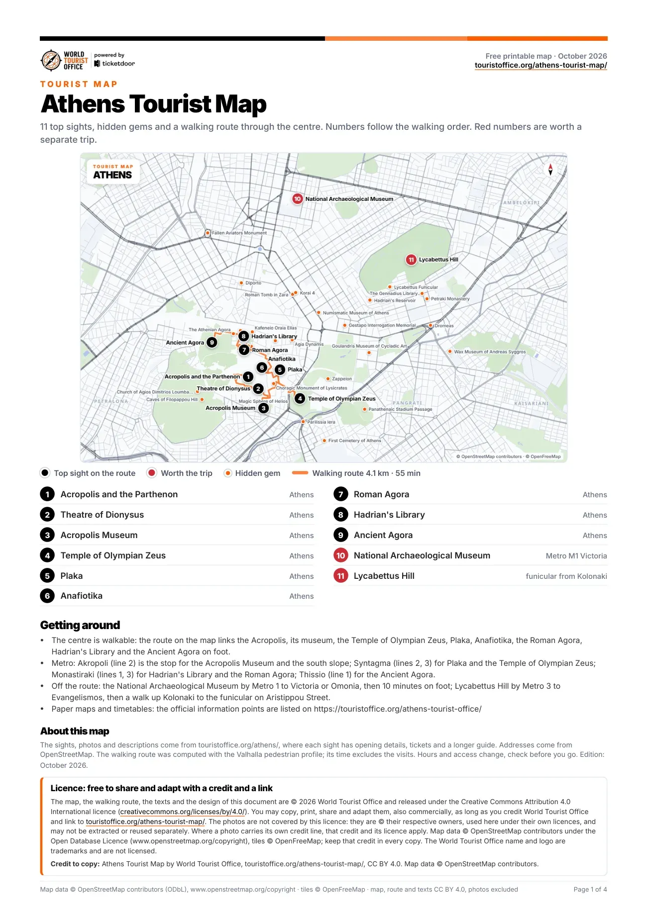
The sights marked on the map of Athens
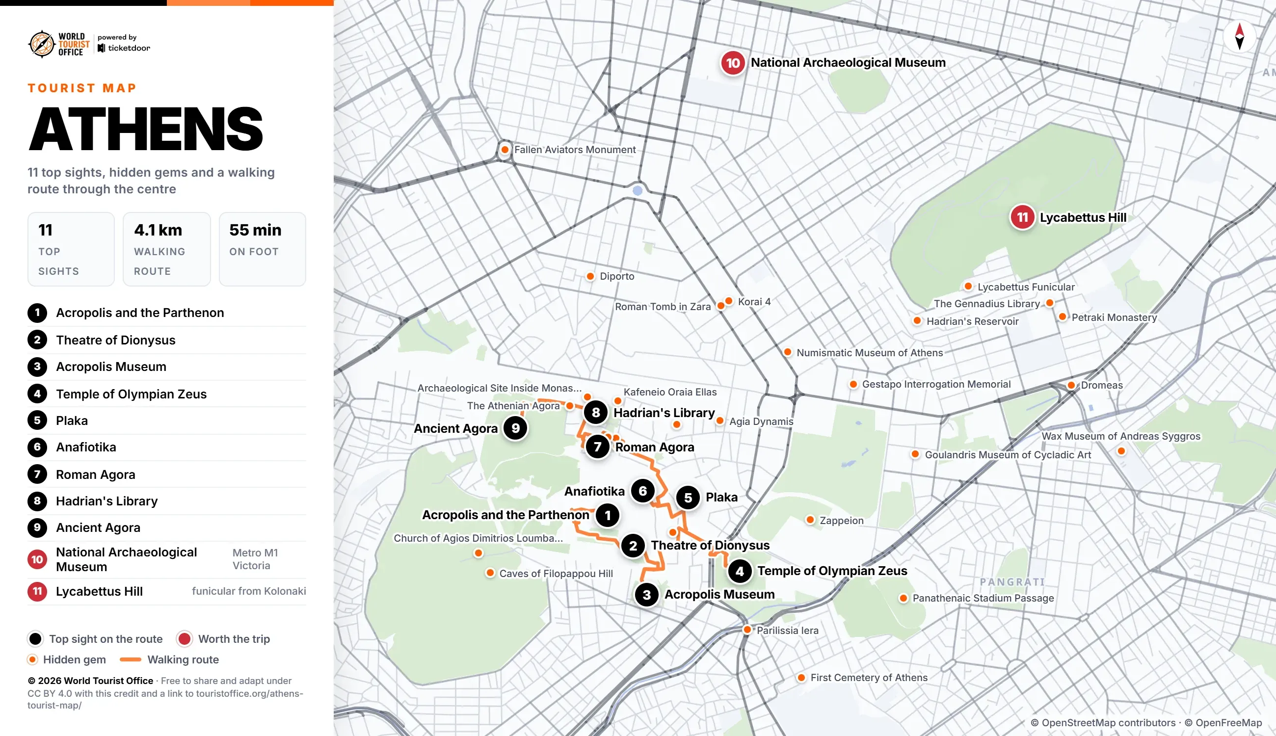
The numbers below match the pins on the map, the PDF and the video. The first 9 sights sit on the walking route through the centre and are reached on foot; the last 2 are reached by metro or funicular.
- Acropolis and the Parthenon, Acropolis hill. The limestone rock the city grew around, crowned by the Parthenon, the Erechtheion and the Propylaea. Stop 1 of the walking route.
- Theatre of Dionysus, south slope of the Acropolis. Where Greek drama began, with curved stone tiers, a paved orchestra and marble thrones for priests. Stop 2 of the walking route.
- Acropolis Museum, Makrygianni. The finds from the rock above, from the five Caryatids to the Parthenon frieze, over glass floors. Stop 3 of the walking route.
- Temple of Olympian Zeus, beside the Zappeion gardens. Fifteen Corinthian columns of the colossal temple Hadrian finished in 131 CE, with a sixteenth fallen. Stop 4 of the walking route.
- Plaka, north slope of the Acropolis. The oldest inhabited quarter of Athens, with pedestrian lanes, neoclassical houses and small Byzantine churches. Stop 5 of the walking route.
- Anafiotika, above Plaka. A village of whitewashed houses and stepped lanes built by islanders from Anafi, right under the rock. Stop 6 of the walking route.
- Roman Agora, Plaka. The market square paid for by Julius Caesar and Augustus, entered through the Gate of Athena Archegetis. Stop 7 of the walking route.
- Hadrian's Library, Monastiraki. Hadrian's walled complex of 132 CE, with Corinthian columns still standing along Areos Street. Stop 8 of the walking route.
- Ancient Agora, Thiseio. The civic heart of the ancient city, with the Temple of Hephaestus and the rebuilt Stoa of Attalos. Stop 9 of the walking route.
- National Archaeological Museum, Exarcheia. The largest archaeological collection in Greece, from the Mask of Agamemnon to the frescoes of Akrotiri. Off the route: Metro line 1 to Victoria or Omonia (0.7 km north-east of the centre).
- Lycabettus Hill, Kolonaki. The highest point in central Athens, a cone of pines with the chapel of Agios Georgios on top. Off the route: funicular from Aristippou street in Kolonaki (1.7 km east of the centre).
Hidden gems on the map
Marked in orange on the map: 32 smaller sights worth a detour. The PDF lists all of them with addresses.
- The Athenian Agora, Adrianou
- Antikythera Mechanism, Patision
- Lycabettus Funicular, Aristippou
- Tower of the Winds, Polygnotou
- Magic Sphere of Helios, Dionysiou Areopagitou
- Hadrian's Reservoir, Xanthippou
- Dromeas (The Runner), Vasilissis Sofias
- First Cemetery of Athens, Longinou
- Agia Dynamis, Mitropoleos
- Roman Tomb in Zara, Korai
- Old Madrasa of Athens, Pelopida
- Panathenaic Stadium Passage, Plateia Stadiou
- Goulandris Museum of Cycladic Art, Neofytou Douka
- Little Metropolis Church, Plateia Mitropoleos
- Church of Agios Dimitrios Loumbardiaris (Saint Demetrius the Bombardier), Filopappou Hill
- Wax Museum of Andreas Syggros, Ionos Dragoumi
- Diporto, Sokratous
- Caves of Filopappou Hill
- Petraki Monastery, Gennadiou Ioanni
- Zappeion, Vasilissis Olgas
How to reach every sight on the map
The centre is walkable: the 9 stops on the route cover 4.1 km, about 55 min of walking without the visits, and the longest leg is the 0.8 km from Anafiotika down to the Roman Agora.
The metro, run by STASY, has three lines through the centre. Line 2 stops at Akropoli, for the Acropolis, the Theatre of Dionysus and the Acropolis Museum, and at Syntagma, which it shares with line 3, on the edge of Plaka. Lines 1 and 3 meet at Monastiraki, for Hadrian's Library, and line 1 continues to Thissio, the area of the Thiseio Square gate of the Ancient Agora. Anafiotika and the Roman Agora sit between the stations and are easiest on foot.
Sights outside the walking route:
- National Archaeological Museum: Metro line 1 to Victoria or Omonia, 0.7 km north-east
- Lycabettus Hill: funicular from Aristippou street in Kolonaki, 1.7 km east
Athens transport map by OASA, Transport for Athens >
Licence
The map, the PDF, the walking route and the texts are © 2026 World Tourist Office and free to copy, share, print and adapt, also commercially, under Creative Commons Attribution 4.0 International. The only condition is a credit to World Tourist Office with a link to this page.
The photos are not covered by this licence: they are © their respective owners, used here under their own licences, and may not be extracted or reused separately. Where a photo carries its own credit line, that credit and its licence apply. Map data © OpenStreetMap contributors (ODbL), tiles © OpenFreeMap: keep that credit too. The World Tourist Office name and logo are trademarks and are not licensed.
Credit to copy: Athens Tourist Map by World Tourist Office, touristoffice.org/athens-tourist-map/, CC BY 4.0. Map data © OpenStreetMap contributors.