What the numbers on the Windsor tourist map mean
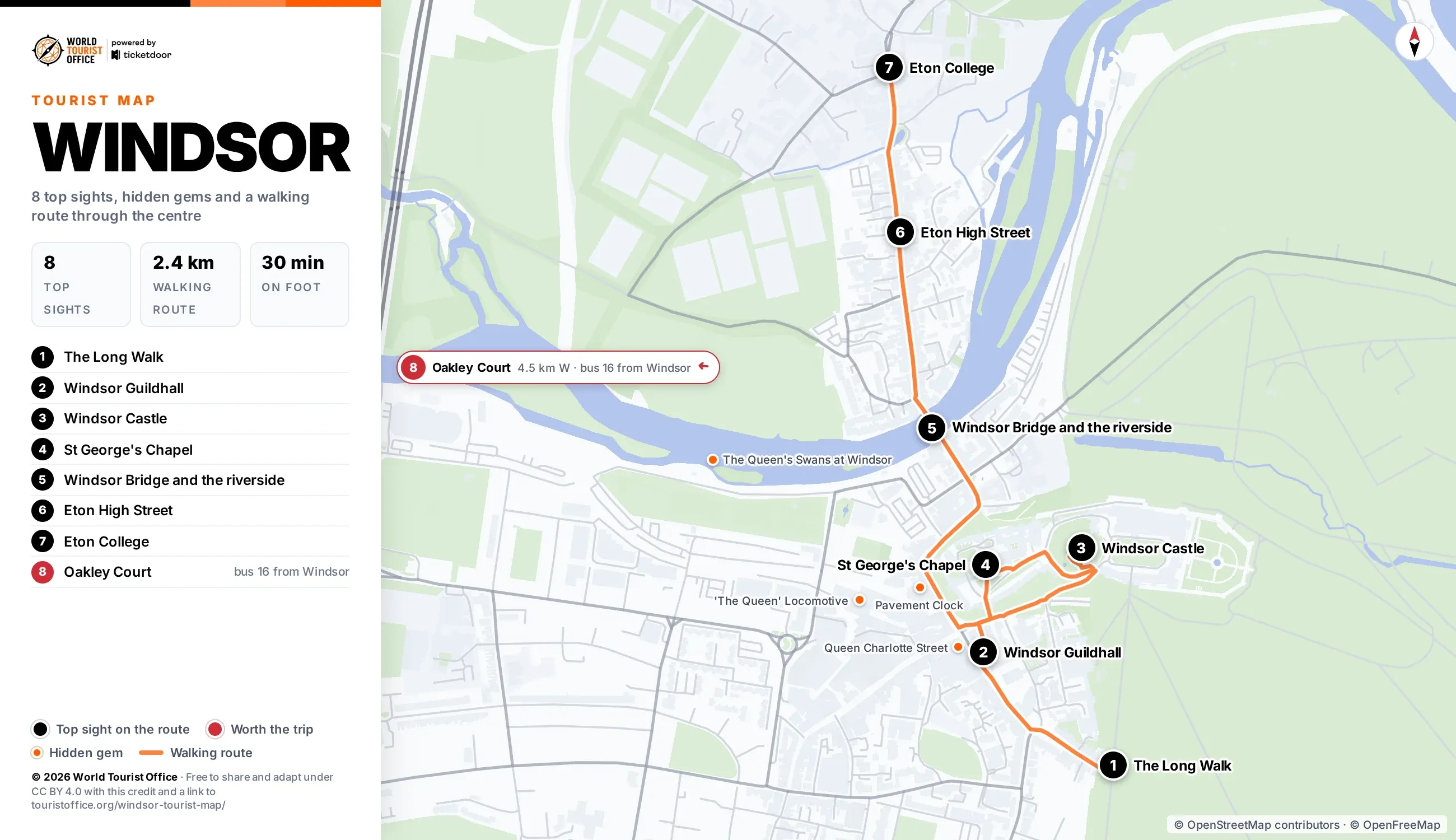
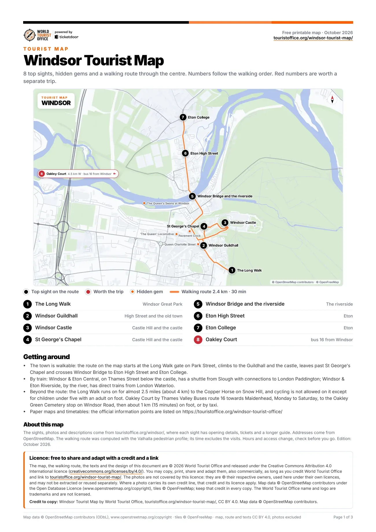
The numbers below match the pins on the map, the PDF and the video. The first 7 sights sit on the walking route, from the gates of the Long Walk through the castle and across Windsor Bridge to Eton; the last one, Oakley Court, is a bus ride west of the town.
- The Long Walk, Windsor Great Park. Charles II's straight tree-lined avenue, running south through the Deer Park to the Copper Horse statue. Stop 1 of the walking route.
- Windsor Guildhall, High Street. Grade I listed hall on Portland stone columns, home to Windsor Guildhall Museum. Stop 2 of the walking route.
- Windsor Castle, Castle Hill. Founded by William the Conqueror in the 11th century, the oldest and largest occupied castle in the world. Stop 3 of the walking route.
- St George's Chapel, Lower Ward of Windsor Castle. Late medieval chapel of the Order of the Garter, the last stop inside the castle walls. Stop 4 of the walking route.
- Windsor Bridge and the riverside, between Thames Street and Eton. Cast iron bridge of 1824 between Windsor and Eton, closed to cars since 1970 and open to walkers. Stop 5 of the walking route.
- Eton High Street, Eton. Eton's main street of brick houses, antique shops and old inns, running from the bridge to the college. Stop 6 of the walking route.
- Eton College, Eton. The school Henry VI founded in 1440, its brick ranges grouped around School Yard and the College Chapel. Stop 7 of the walking route.
- Oakley Court, Water Oakley, near Bray. Victorian Gothic mansion of 1859 on the Thames, now a hotel in 35 acres of grounds. Off the route: Thames Valley Buses route 16 towards Maidenhead, Monday to Saturday, to the Oakley Green Cemetery stop, then about 1 km on foot (4.5 km west of the centre).
Hidden gems on the map
Marked in orange: 6 smaller sights worth a detour. The first 4 are in the centre and on the map; the last 2, at Runnymede, fall outside its frame and appear only in the PDF, which lists all 6 with their addresses.
- The Queen's Swans at Windsor, Barry Avenue
- Queen Charlotte Street, off the High Street
- 'The Queen' Locomotive, Windsor & Eton Central station, Thames Street
- Pavement Clock, Thames Street
- The JFK Memorial at Runnymede, Windsor Road, Old Windsor
- Ankerwycke Yew, Magna Carta Lane, Wraysbury
How to get around Windsor with this map
Windsor and Eton are walkable: the 7 stops on the route cover 2.4 km, about 30 min without the visits, and the longest leg is the 0.6 km from St George's Chapel down Thames Street to Windsor Bridge. Castle Hill is steep, and the bridge is open only to people on foot and cyclists.
There is no metro. Both railway stations are a few minutes' walk from the castle: Windsor & Eton Central, on Thames Street, has a Great Western Railway branch line shuttle from Slough, where trains from London Paddington connect, and Windsor & Eton Riverside has direct South Western Railway trains from London Waterloo. Local buses stop in the town centre.
Sights outside the walking route:
- Oakley Court: Thames Valley Buses route 16 towards Maidenhead, Monday to Saturday, to the Oakley Green Cemetery stop on Windsor Road, then about 1 km on foot, 4.5 km west
Bus routes and network map of the Royal Borough of Windsor and Maidenhead >
Licence
The map, the PDF, the walking route and the texts are © 2026 World Tourist Office and free to copy, share, print and adapt, also commercially, under Creative Commons Attribution 4.0 International. The only condition is a credit to World Tourist Office with a link to this page.
The photos are not covered by this licence: they are © their respective owners, used here under their own licences, and may not be extracted or reused separately. Where a photo carries its own credit line, that credit and its licence apply. Map data © OpenStreetMap contributors (ODbL), tiles © OpenFreeMap: keep that credit too. The World Tourist Office name and logo are trademarks and are not licensed.
Two photos in the PDF and the video carry their own credit: Windsor Guildhall, "Guildhall, Windsor, England" by Diego Delso, licensed under CC BY-SA 4.0; Eton High Street, "High Street in Eton" by Steve Daniels, licensed under CC BY-SA 2.0.
Credit to copy: Windsor Tourist Map by World Tourist Office, touristoffice.org/windsor-tourist-map/, CC BY 4.0. Map data © OpenStreetMap contributors.