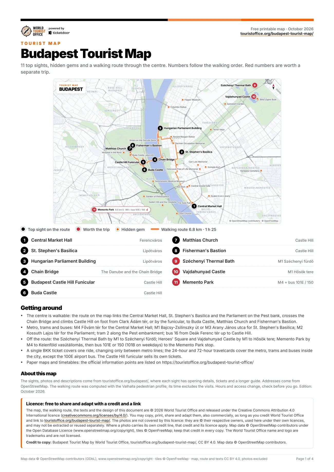
Map of Budapest attractions, numbered
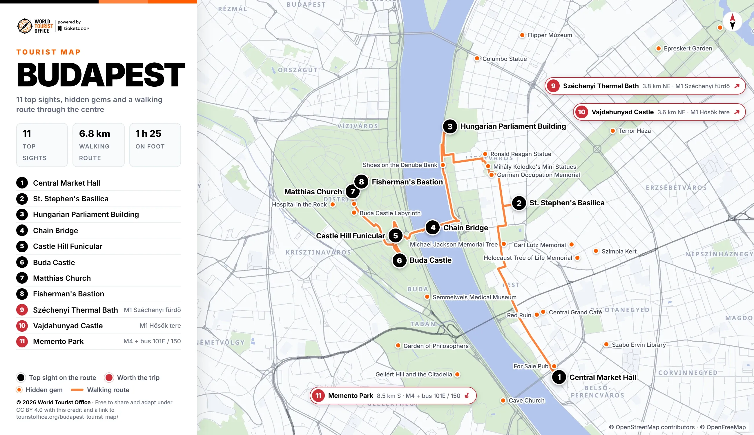
The numbers below match the pins on the map, the PDF and the video. The first 8 sights sit on the walking route, from the Pest bank across the Chain Bridge to Castle Hill; the last 3 are a metro ride away, Memento Park with a bus at the end.
- Central Market Hall, Fővám tér, Ferencváros. Budapest's largest and oldest indoor market, a neo-Gothic hall of 1897 under a roof of Zsolnay tiles. Stop 1 of the walking route.
- St. Stephen's Basilica, Lipótváros. The largest Catholic church in the city, keeper of the mummified right hand of King Stephen. Stop 2 of the walking route.
- Hungarian Parliament Building, Lipótváros. Imre Steindl's Gothic Revival parliament on the Danube, with the Hungarian crown jewels under its dome. Stop 3 of the walking route.
- Chain Bridge, between Clark Ádám tér and Széchenyi István tér. William Tierney Clark's suspension bridge of 1849, the first permanent crossing between Buda and Pest. Stop 4 of the walking route.
- Budapest Castle Hill Funicular, Castle Hill. The cable railway of 1870 that climbs from the river bank to the palace terrace. Stop 5 of the walking route.
- Buda Castle, Castle Hill. The former royal palace, home to the Hungarian National Gallery and the Budapest History Museum. Stop 6 of the walking route.
- Matthias Church, Castle Hill. The Zsolnay-roofed church where Franz Joseph I and Charles IV were crowned kings of Hungary. Stop 7 of the walking route.
- Fisherman's Bastion, Castle Hill. Frigyes Schulek's neo-Romanesque lookout terrace, its seven towers facing the Parliament across the Danube. Stop 8 of the walking route.
- Széchenyi Thermal Bath, City Park. The neo-Baroque bathhouse of City Park, with three outdoor pools open all year. Off the route: M1 to Széchenyi fürdő (3.8 km north-east of the centre).
- Vajdahunyad Castle, City Park. Ignác Alpár's castle from the millennium exhibition, copying buildings from across historic Hungary. Off the route: M1 to Hősök tere (3.6 km north-east of the centre).
- Memento Park, Budatétény, District XXII. Communist-era statues removed from the city's squares after 1989, gathered in an open-air park. Off the route: M4 to Kelenföld vasútállomás, then bus 101E or 150 (8.5 km south of the centre).
Hidden gems on the map
Marked in orange on the map: 34 smaller sights worth a detour. The 20 below are the ones in or near the centre; the PDF lists all 34 with their addresses.
- For Sale Pub, Vámház körút
- Shoes on the Danube Bank, Id. Antall József rakpart
- Buda Castle Labyrinth, Úri utca
- Szimpla Kert, Kazinczy utca
- Szabó Ervin Library, Szabó Ervin tér
- Cave Church, Szent Gellért rakpart
- Gellért Hill and the Citadella, Citadella sétány
- Terror Háza, Andrássy út
- Red Ruin, Irányi utca
- Centrál Grand Café, Károlyi utca
- Flipper Múzeum, Radnóti Miklós utca
- Columbo Statue, Falk Miksa utca
- Garden of Philosophers, Gellért Hill
- Hospital in the Rock, Lovas út
- Semmelweis Medical Museum, Apród utca
- Golden Eagle Pharmacy Museum, Tárnok utca
- Michael Jackson Memorial Tree, Erzsébet tér
- Ronald Reagan Statue, Szabadság tér
- Péter Mansfeld Monument, Szabó Ilonka utca
- Mihály Kolodko's Mini Statues, Szabadság tér and other spots in the centre
Walking, metro and buses between the sights
The centre is walkable: the 8 stops on the route cover 6.8 km, about 1 h 25 without the visits, and the longest leg is the 2.0 km from the Central Market Hall to St. Stephen's Basilica. The route climbs Castle Hill on foot from Clark Ádám tér; the funicular makes the same climb and sells its own tickets.
BKK runs the metro, trams and buses. M4 stops at Fővám tér by the market hall, M1 at Bajcsy-Zsilinszky út and M3 at Arany János utca near the basilica, and M2 at Kossuth Lajos tér beside the Parliament. Tram 2 runs along the Pest embankment between them, and bus 16 climbs from Deák Ferenc tér to Dísz tér and Szentháromság tér on Castle Hill.
Sights outside the walking route:
- Széchenyi Thermal Bath: M1 to Széchenyi fürdő, 3.8 km north-east
- Vajdahunyad Castle: M1 to Hősök tere, 3.6 km north-east
- Memento Park: M4 to Kelenföld vasútállomás, then bus 101E or 150 (101B on weekdays) to the Memento Park stop, 8.5 km south
Metro, suburban railway and tram network maps by BKK >
Licence
The map, the PDF, the walking route and the texts are © 2026 World Tourist Office and free to copy, share, print and adapt, also commercially, under Creative Commons Attribution 4.0 International. The only condition is a credit to World Tourist Office with a link to this page.
The photos are not covered by this licence: they are © their respective owners, used here under their own licences, and may not be extracted or reused separately. Where a photo carries its own credit line, that credit and its licence apply. Map data © OpenStreetMap contributors (ODbL), tiles © OpenFreeMap: keep that credit too. The World Tourist Office name and logo are trademarks and are not licensed.
One photo in the PDF and the video carries its own credit: Memento Park, "Main entrance of the Memento Park with Lenin, Marx and Engels" by Ferran Cornellà, licensed under CC BY-SA 3.0.
Credit to copy: Budapest Tourist Map by World Tourist Office, touristoffice.org/budapest-tourist-map/, CC BY 4.0. Map data © OpenStreetMap contributors.