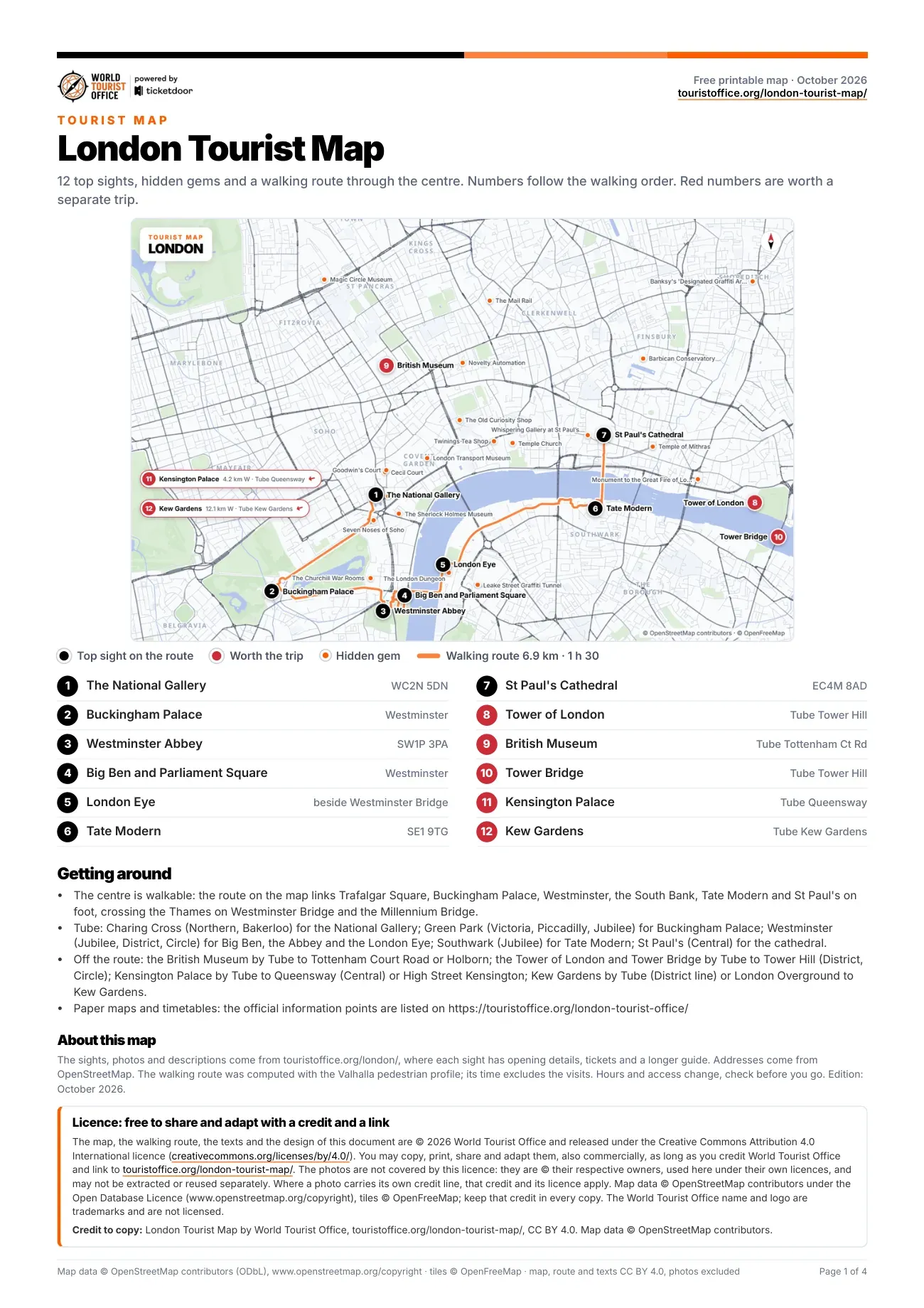
What the numbers on the London tourist map mean
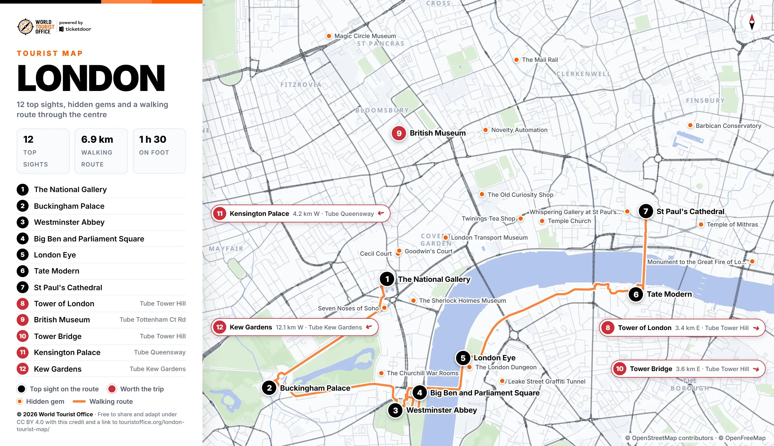
The numbers below match the pins on the map, the PDF and the video. The first 7 sights sit on the walking route through the centre; the other 5 are a Tube ride away, and Kew Gardens is also on London Overground.
- The National Gallery, Trafalgar Square. The national collection of European painting, free to enter, from Van Eyck and Leonardo to Van Gogh. Stop 1 of the walking route.
- Buckingham Palace, The Mall. The King's official London residence, with State Rooms open to visitors for a few weeks each summer. Stop 2 of the walking route.
- Westminster Abbey, Westminster. The coronation church since 1066, with Poets' Corner; closed to sightseeing on Sundays as a working church. Stop 3 of the walking route.
- Big Ben and Parliament Square, Westminster. The great bell in the Elizabeth Tower of the Palace of Westminster, facing Parliament Square and its statues. Stop 4 of the walking route.
- London Eye, South Bank. The 135 metre observation wheel by the Thames, turning since 2000, one rotation in about half an hour. Stop 5 of the walking route.
- Tate Modern, Bankside. The former Bankside Power Station, now the national gallery of modern art, with free collection displays. Stop 6 of the walking route.
- St Paul's Cathedral, City of London. Wren's cathedral, rebuilt after the Great Fire of 1666, with 528 steps up to the Golden Gallery. Stop 7 of the walking route.
- Tower of London, Tower Hill. The Norman fortress by the Thames that guards the Crown Jewels, with Yeoman Warder tours included. Off the route: Tube to Tower Hill (3.4 km east of the centre).
- British Museum, Bloomsbury. Two million years of human history, from the Rosetta Stone to Sutton Hoo, free to enter. Off the route: Tube to Tottenham Court Road or Holborn (1.4 km north of the centre).
- Tower Bridge, beside the Tower of London. The 1894 bascule bridge, with glass-floored walkways 42 metres above the river and Victorian engine rooms. Off the route: Tube to Tower Hill (3.6 km east of the centre).
- Kensington Palace, Kensington Gardens. Wren's royal palace where Queen Victoria was born; the Queen's State Apartments are closed until spring 2027. Off the route: Tube to Queensway or High Street Kensington (4.2 km west of the centre).
- Kew Gardens, Kew, Richmond. The Royal Botanic Gardens, a World Heritage Site; the Palm House stays open ahead of a 2027 renovation. Off the route: District line or London Overground to Kew Gardens (12.1 km west of the centre).
Hidden gems on the map
Marked in orange on the map: 29 smaller sights worth a detour, 17 of them close to the centre. The 17 central ones come first below, then the next three by distance; the PDF lists all of them with addresses.
- Twinings Tea Shop, Strand
- Cecil Court, between Charing Cross Road and St Martin's Lane
- The Churchill War Rooms, King Charles Street
- Goodwin's Court, off St Martin's Lane
- Magic Circle Museum, Stephenson Way
- The Sherlock Holmes Museum, inside the Sherlock Holmes pub, Northumberland Street
- Novelty Automation, Princeton Street
- The London Dungeon, Westminster Bridge Road
- Temple Church, Inner Temple Lane
- Café in the Crypt, Trafalgar Square
- The Mail Rail, Phoenix Place
- The Old Curiosity Shop, Portsmouth Street
- Seven Noses of Soho, one of them on Admiralty Arch, The Mall
- Whispering Gallery at St Paul's Cathedral, St Paul's Churchyard
- Leake Street Graffiti Tunnel, under Waterloo station
- Temple of Mithras, Walbrook
- London Transport Museum, Covent Garden Piazza
- Platform 9 3/4, King's Cross station, Euston Road
- Barbican Conservatory, Silk Street
- Monument to the Great Fire of London, Fish Street Hill
Walking, metro and buses between the sights
The centre is walkable: the 7 stops of the route cover 6.9 km, about 1 h 30 on foot, and cross the Thames on Westminster Bridge and the Millennium Bridge. The longest leg is the 1.8 km from the London Eye to Tate Modern along the south bank.
By Tube, Charing Cross (Bakerloo and Northern lines) serves The National Gallery, Green Park (Jubilee, Piccadilly and Victoria) Buckingham Palace, Westminster (Circle, District and Jubilee) the Abbey, Big Ben and the London Eye, Southwark (Jubilee) Tate Modern and St Paul's (Central) the cathedral. Bus 15 links Charing Cross, by Trafalgar Square, with St Paul's Cathedral and the Tower of London.
Sights outside the walking route:
- Tower of London: Tube to Tower Hill (District, Circle), 3.4 km east
- British Museum: Tube to Tottenham Court Road (Central, Northern, Elizabeth line) or Holborn (Central, Piccadilly), 1.4 km north
- Tower Bridge: Tube to Tower Hill (District, Circle), 3.6 km east
- Kensington Palace: Tube to Queensway (Central) or High Street Kensington (Circle, District), 4.2 km west
- Kew Gardens: District line or London Overground (Mildmay line) to Kew Gardens, 12.1 km west
Tube map by Transport for London >
Licence
The map, the PDF, the walking route and the texts are © 2026 World Tourist Office and free to copy, share, print and adapt, also commercially, under Creative Commons Attribution 4.0 International. The only condition is a credit to World Tourist Office with a link to this page.
The photos are not covered by this licence: they are © their respective owners, used here under their own licences, and may not be extracted or reused separately. Where a photo carries its own credit line, that credit and its licence apply. Map data © OpenStreetMap contributors (ODbL), tiles © OpenFreeMap: keep that credit too. The World Tourist Office name and logo are trademarks and are not licensed.
Credit to copy: London Tourist Map by World Tourist Office, touristoffice.org/london-tourist-map/, CC BY 4.0. Map data © OpenStreetMap contributors.