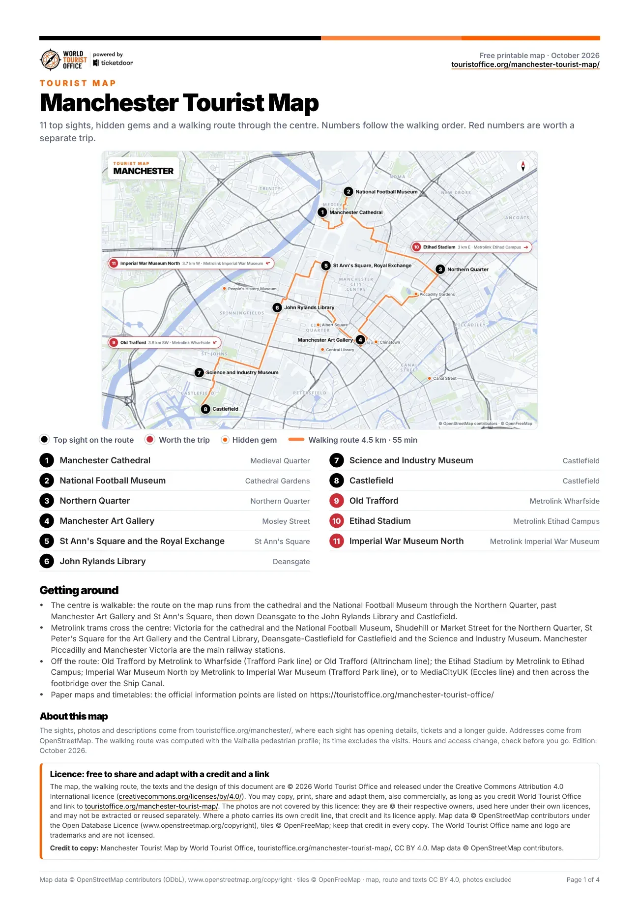
The 11 sights on the Manchester attractions map
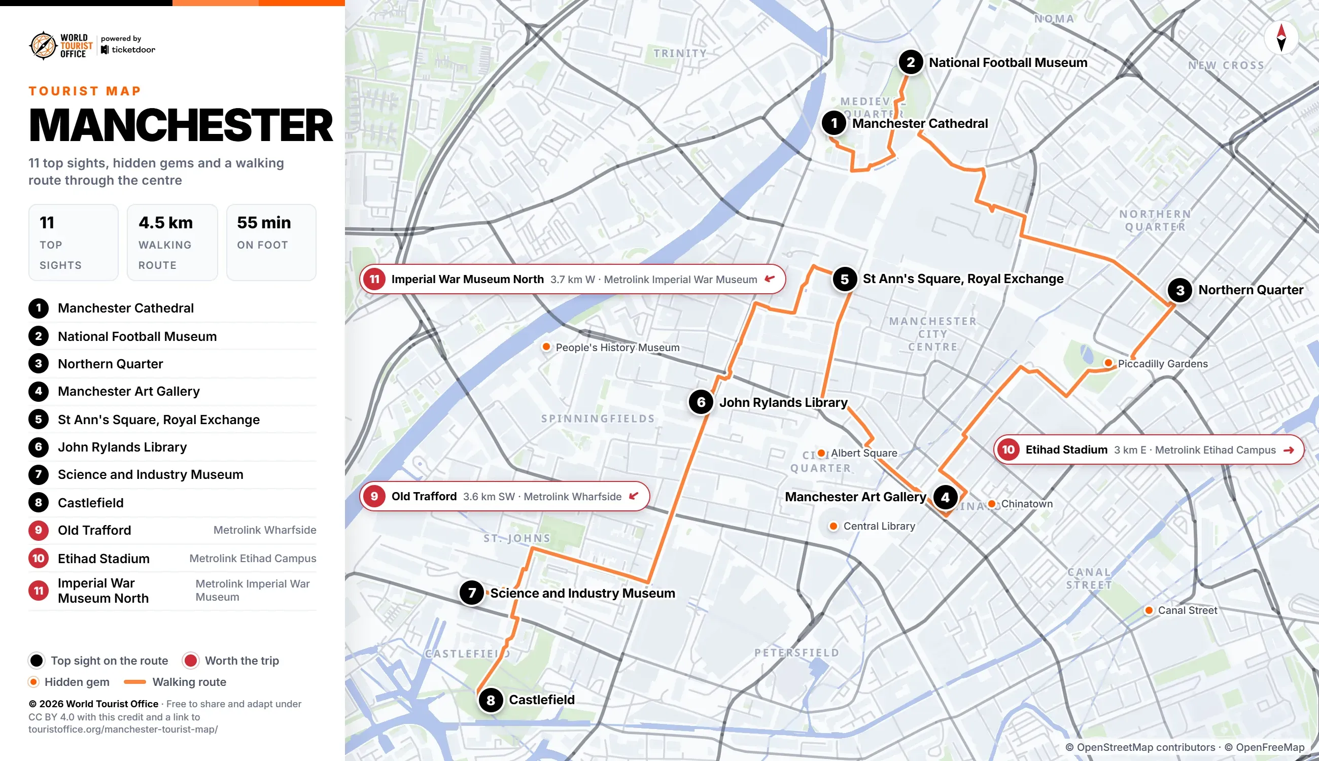
The numbers below match the pins on the map, the PDF and the video. The first 8 sights are stops on the walking route, from the cathedral quarter through the Northern Quarter and the shopping streets to Deansgate and Castlefield. The other 3 lie outside the centre and are reached by Metrolink tram: Old Trafford to the south-west, the Etihad Stadium to the east and Imperial War Museum North to the west.
- Manchester Cathedral, Medieval Quarter. Gothic cathedral beside the River Irwell, with carved choir stalls, next to the medieval Chetham's Library. Stop 1 of the walking route.
- National Football Museum, Cathedral Gardens. Football museum in the glass Urbis building in Cathedral Gardens, in Manchester since 2012. Stop 2 of the walking route.
- Northern Quarter, Oldham Street. Former Victorian warehouse streets of independent shops, record stores, cafes and murals around Stevenson Square. Stop 3 of the walking route.
- Manchester Art Gallery, Mosley Street. Free gallery in Charles Barry's neoclassical rooms, strongest in Pre-Raphaelite art. Stop 4 of the walking route.
- St Ann's Square and the Royal Exchange, between Deansgate and the cathedral. Georgian square around St Ann's Church, the former Cotton Exchange on the east side of its northern end. Stop 5 of the walking route.
- John Rylands Library, Deansgate. Neo-Gothic library of 1900 halfway along Deansgate, free to enter, with a vaulted Historic Reading Room. Stop 6 of the walking route.
- Science and Industry Museum, Castlefield. Museum of industry in Liverpool Road station of 1830, the oldest surviving passenger railway station in the world. Stop 7 of the walking route.
- Castlefield, Liverpool Road. Canal basins, iron bridges and warehouses on the site of the Roman fort of Mamucium. Stop 8 of the walking route.
- Old Trafford, Sir Matt Busby Way, Trafford. Manchester United's stadium since 1910, the Theatre of Dreams, with a stadium tour and museum. Off the route: Metrolink tram to Wharfside (3.6 km south-west of the centre).
- Etihad Stadium, Etihad Campus. Manchester City's home since 2003, built for the 2002 Commonwealth Games, with stadium tours. Off the route: Metrolink tram to Etihad Campus (3.0 km east of the centre).
- Imperial War Museum North, The Quays, Trafford Wharf. Daniel Libeskind's aluminium museum of three shards on the Trafford side of the Quays, free to enter. Off the route: Metrolink tram to Imperial War Museum (3.7 km west of the centre).
Hidden gems on the map
Marked in orange: 10 smaller sights worth a detour. The first 6 below are on the map of the centre and the last 4 lie outside its frame; the PDF lists all 10 with their addresses.
- Central Library, St Peter's Square
- People's History Museum, Left Bank, Spinningfields
- Piccadilly Gardens, at the southern edge of the Northern Quarter
- Albert Square, next to St Peter's Square
- Chinatown, Faulkner Street
- Canal Street, along the Rochdale Canal
- Manchester Museum, Oxford Road
- The Whitworth, Whitworth Park, Oxford Road
- The Lowry Galleries, Pier 8, Salford Quays
- Heaton Park, Middleton Road, north Manchester
Getting to the sights on the Manchester tourist map
The centre is compact: the 8 stops on the route cover 4.5 km, about 55 min on foot without the visits. The longest leg is the 0.9 km from the National Football Museum to the Northern Quarter.
Metrolink trams cross the centre. Exchange Square and Victoria serve the cathedral and the National Football Museum, Shudehill and Market Street the Northern Quarter, St Peter's Square the Art Gallery, and Deansgate-Castlefield the Science and Industry Museum and Castlefield.
Sights outside the walking route:
- Old Trafford: Metrolink to Wharfside, on The Trafford Centre - Crumpsall line, a short walk from the stadium, 3.6 km south-west
- Etihad Stadium: Metrolink to Etihad Campus, on the Ashton-under-Lyne - Bury and Altrincham - Etihad Campus lines, right beside the ground, 3.0 km east
- Imperial War Museum North: Metrolink to Imperial War Museum, on The Trafford Centre - Crumpsall line, or to MediaCityUK and the footbridge over the Ship Canal, 3.7 km west
Metrolink network map of Transport for Greater Manchester (TfGM) >
Licence
The map, the PDF, the walking route and the texts are © 2026 World Tourist Office and free to copy, share, print and adapt, also commercially, under Creative Commons Attribution 4.0 International. The only condition is a credit to World Tourist Office with a link to this page.
The photos are not covered by this licence: they are © their respective owners, used here under their own licences, and may not be extracted or reused separately. Where a photo carries its own credit line, that credit and its licence apply. Map data © OpenStreetMap contributors (ODbL), tiles © OpenFreeMap: keep that credit too. The World Tourist Office name and logo are trademarks and are not licensed.
One photo in the PDF and the video carries its own credit: St Ann's Square and the Royal Exchange, "Royal Exchange Manchester central hall" by University of Salford Press Office, licensed under CC BY 2.0.
Credit to copy: Manchester Tourist Map by World Tourist Office, touristoffice.org/manchester-tourist-map/, CC BY 4.0. Map data © OpenStreetMap contributors.