What the numbers on the Paris tourist map mean
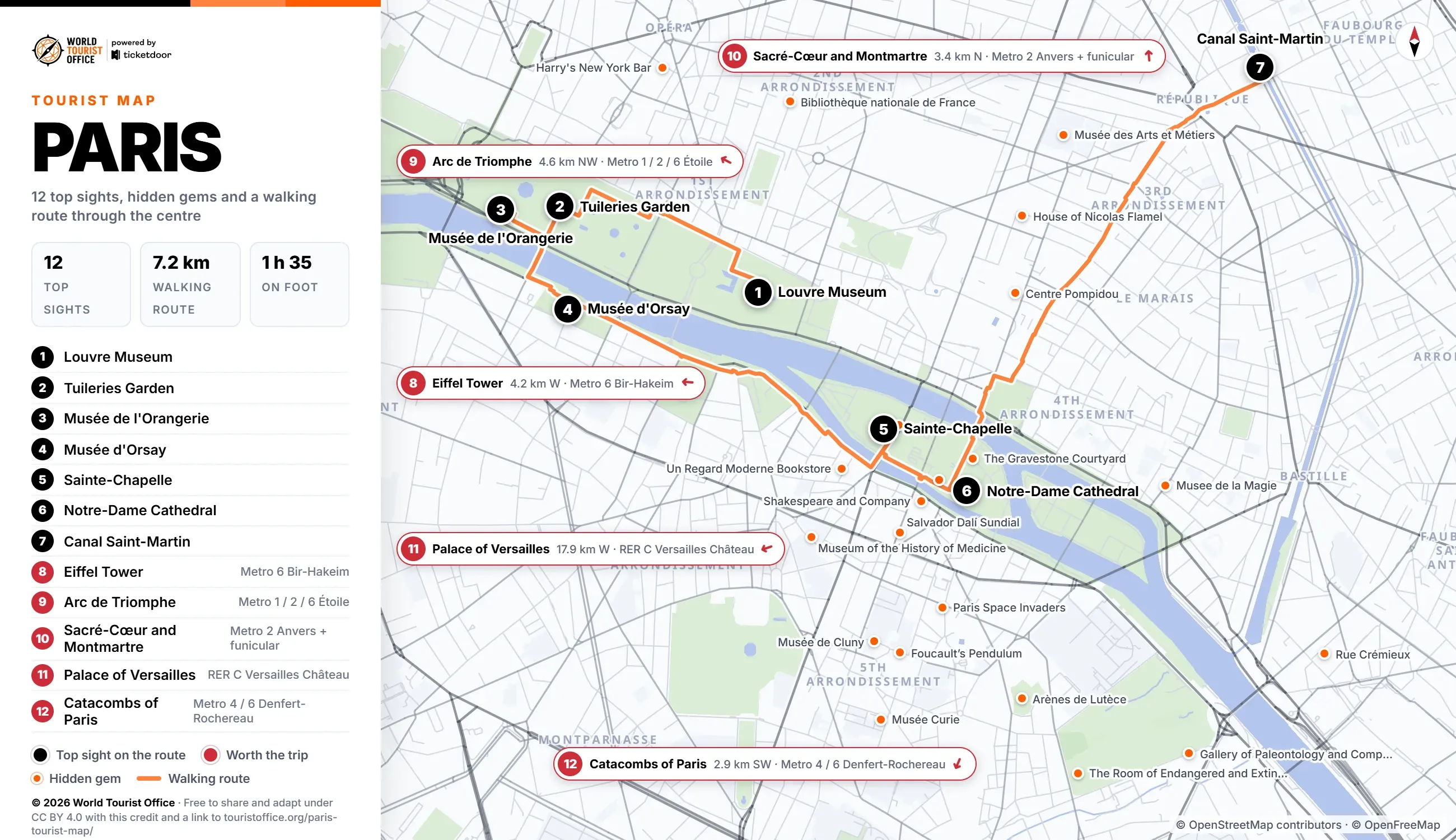
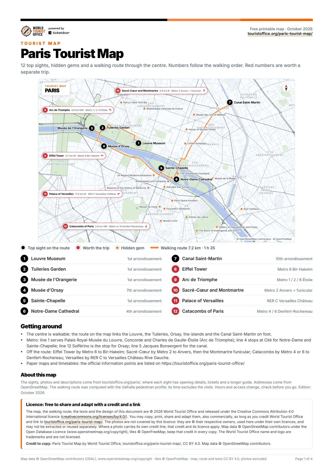
The numbers below match the pins on the map, the PDF and the video. The first 7 sights sit on the walking route through the centre; the last 5 are reached by metro or RER.
- Louvre Museum, 1st arrondissement. The former royal palace and largest museum in the world, spreading from the glass pyramid across three wings. Stop 1 of the walking route.
- Tuileries Garden, 1st arrondissement. Le Nôtre's formal garden of round ponds, clipped hedges and green metal chairs between the Louvre and Concorde. Stop 2 of the walking route.
- Musée de l'Orangerie, 1st arrondissement. The former orangery of the Tuileries, with two oval rooms laid out for Monet's Water Lilies. Stop 3 of the walking route.
- Musée d'Orsay, 7th arrondissement. Victor Laloux's Beaux-Arts railway station of 1900, now the museum of Impressionist and Post-Impressionist painting. Stop 4 of the walking route.
- Sainte-Chapelle, 1st arrondissement. Louis IX's palace chapel inside the law courts, its upper level a cage of fifteen tall windows. Stop 5 of the walking route.
- Notre-Dame Cathedral, 4th arrondissement. The Gothic cathedral on the Île de la Cité, reopened in December 2024 after the restoration. Stop 6 of the walking route.
- Canal Saint-Martin, 10th arrondissement. The canal of 1825, with locks, iron footbridges that swing aside for boats and plane trees. Stop 7 of the walking route.
- Eiffel Tower, 7th arrondissement. The iron tower of the 1889 World's Fair on the Champ de Mars, with three levels open. Off the route: Metro 6 to Bir-Hakeim or RER C to Champ de Mars Tour Eiffel (4.2 km west of the centre).
- Arc de Triomphe, 8th arrondissement. Napoleon's arch over the tomb of the Unknown Soldier, where twelve avenues meet. Off the route: Metro 1, 2 or 6 or RER A to Charles de Gaulle-Étoile (4.6 km north-west of the centre).
- Sacré-Cœur and Montmartre, 18th arrondissement. The white basilica on the highest hill in Paris, above the village streets of Montmartre. Off the route: Metro 2 to Anvers, then the Montmartre funicular (3.4 km north of the centre).
- Palace of Versailles, Versailles. Louis XIV's palace and court from 1682, with the Hall of Mirrors and Le Nôtre's gardens. Off the route: RER C to Versailles Château Rive Gauche (17.9 km west of the centre).
- Catacombs of Paris, 14th arrondissement. The ossuary of some six million Parisians in the old limestone quarries under Montparnasse. Off the route: Metro 4 or 6 or RER B to Denfert-Rochereau (2.9 km south-west of the centre).
Hidden gems on the map
Marked in orange on the map: 36 smaller sights worth a detour. The PDF lists all of them with addresses.
- Shakespeare and Company, Rue de la Bûcherie
- Bibliothèque nationale de France (National Library of France), Rue de Richelieu
- House of Nicolas Flamel, Rue de Montmorency
- Paris Point Zero, Place Jean-Paul II
- Centre Pompidou, Place Georges-Pompidou
- Rue Crémieux, near the Gare de Lyon
- Foucault’s Pendulum, Place du Panthéon
- Museum of the History of Medicine, Rue de l'École de Médecine
- The Room of Endangered and Extinct Species, Rue Geoffroy-Saint-Hilaire
- Gallery of Paleontology and Comparative Anatomy, Rue Buffon
- Un Regard Moderne Bookstore, Rue Gît-le-Cœur
- Musée de Cluny, Rue du Sommerard
- Harry's New York Bar, Rue Daunou
- Musée des Arts et Métiers, Rue Réaumur
- Salvador Dalí Sundial, Rue Saint-Jacques
- Musée de la Magie, Rue Saint-Paul
- The Gravestone Courtyard, Rue Chanoinesse
- Arènes de Lutèce, Rue Monge
- La Conciergerie, Boulevard du Palais
- Musée Curie, Rue Pierre et Marie Curie
Getting to the sights on the Paris tourist map
The centre is walkable: the 7 stops on the route cover 7.2 km, about 1 h 35 of walking without the visits, and the longest leg is the 2.5 km from Notre-Dame Cathedral to Canal Saint-Martin.
The metro, run by RATP, and the RER follow the route: Palais Royal-Musée du Louvre (lines 1 and 7), Tuileries (line 1), Concorde (lines 1, 8 and 12), Solférino (line 12) or Musée d'Orsay (RER C), Cité (line 4) for Sainte-Chapelle and Notre-Dame, and République (lines 3, 5, 8, 9 and 11) or Jacques Bonsergent (line 5) for the canal.
Sights outside the walking route:
- Eiffel Tower: Metro 6 to Bir-Hakeim or RER C to Champ de Mars Tour Eiffel, 4.2 km west
- Arc de Triomphe: Metro 1, 2 or 6 or RER A to Charles de Gaulle-Étoile, 4.6 km north-west
- Sacré-Cœur and Montmartre: Metro 2 to Anvers, then the Montmartre funicular, 3.4 km north
- Palace of Versailles: RER C to Versailles Château Rive Gauche, then 10 minutes on foot, 17.9 km west
- Catacombs of Paris: Metro 4 or 6 or RER B to Denfert-Rochereau, 2.9 km south-west
Metro map of Paris by RATP >
Licence
The map, the PDF, the walking route and the texts are © 2026 World Tourist Office and free to copy, share, print and adapt, also commercially, under Creative Commons Attribution 4.0 International. The only condition is a credit to World Tourist Office with a link to this page.
The photos are not covered by this licence: they are © their respective owners, used here under their own licences, and may not be extracted or reused separately. Where a photo carries its own credit line, that credit and its licence apply. Map data © OpenStreetMap contributors (ODbL), tiles © OpenFreeMap: keep that credit too. The World Tourist Office name and logo are trademarks and are not licensed.
Credit to copy: Paris Tourist Map by World Tourist Office, touristoffice.org/paris-tourist-map/, CC BY 4.0. Map data © OpenStreetMap contributors.