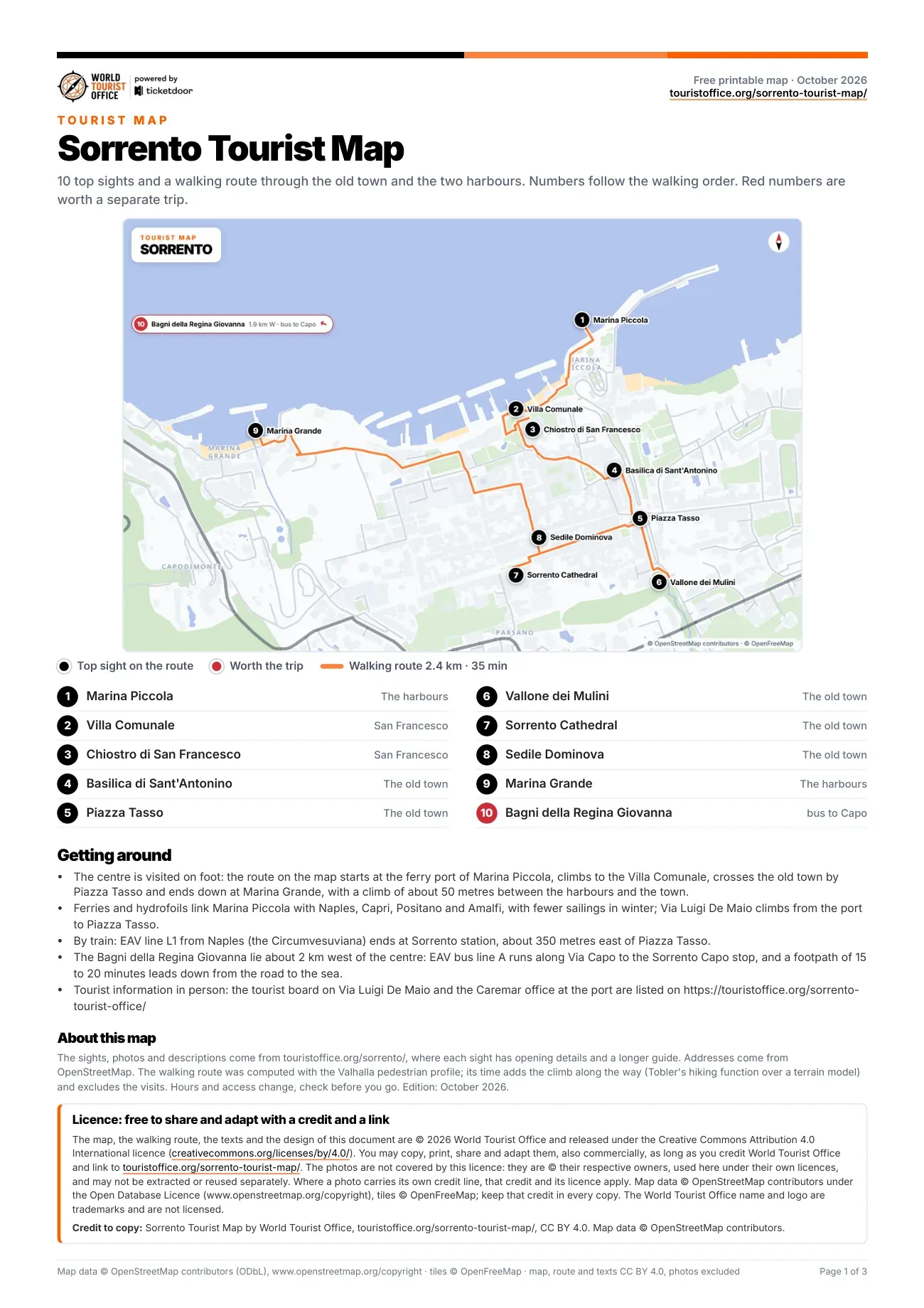
The sights marked on the map of Sorrento
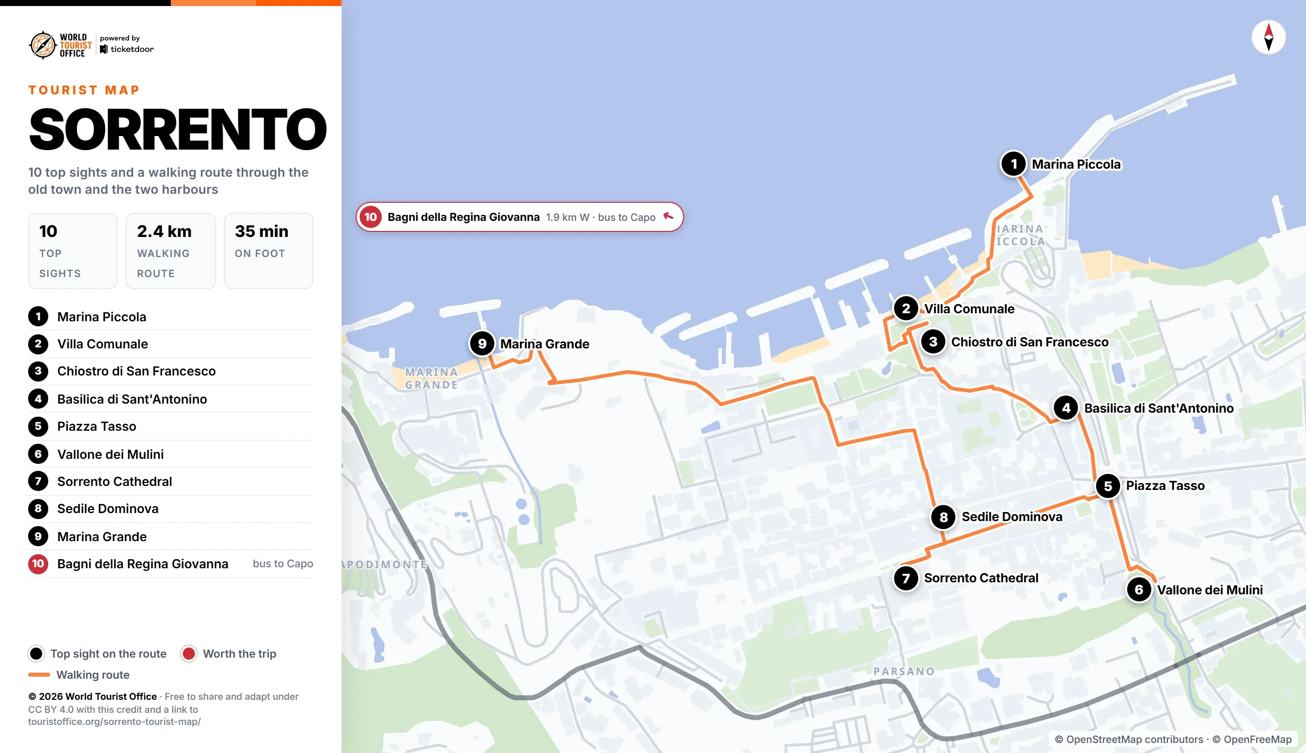
The numbers below match the pins on the map, the PDF and the video. There is no metro in Sorrento: the first 9 sights are seen on foot along the walking route, up from the ferry port to the old town and down to the fishing harbour, and the last one, the Bagni della Regina Giovanna, is a bus ride and a footpath west of the town.
- Marina Piccola, below Piazza Tasso. Sorrento's working harbour, where ferries and hydrofoils tie up for Naples, Capri, Positano and Amalfi. Stop 1 of the walking route.
- Villa Comunale, Via San Francesco. Clifftop park of 1877 to 1879 on the old friars' gardens, a terrace over the Gulf of Naples. Stop 2 of the walking route.
- Chiostro di San Francesco, Via San Francesco. Medieval cloister beside the church of San Francesco, remodelled in the 15th century and used for concerts. Stop 3 of the walking route.
- Basilica di Sant'Antonino, Piazza Sant'Antonino. Basilica of the patron saint, buried in its crypt, with whale bones kept in the entrance porch. Stop 4 of the walking route.
- Piazza Tasso, the old town. Main square named after the poet Torquato Tasso, laid out in the 19th century over a gorge. Stop 5 of the walking route.
- Vallone dei Mulini, behind Piazza Tasso. Deep tufa gorge with the ruins of old mills at the bottom, seen from the railing above. Stop 6 of the walking route.
- Sorrento Cathedral, the old town. Cathedral of Saints Philip and James, with 1930s inlaid choir stalls and the font where Tasso was baptised. Stop 7 of the walking route.
- Sedile Dominova, Via San Cesareo. Open loggia with frescoed walls under a dome of yellow and green tiles, seen from the street. Stop 8 of the walking route.
- Marina Grande, the western edge of the town. The old fishing harbour, its houses packed against the cliff around the small church of Sant'Anna. Stop 9 of the walking route.
- Bagni della Regina Giovanna, Capo di Sorrento. Natural sea pool linked to the sea under a rock arch, beside the ruins of a Roman villa. Off the route: EAV bus line A along Via Capo to the Sorrento Capo stop, then a footpath of 15 to 20 minutes (1.9 km west of the centre).
How to reach every sight on the map
The centre of Sorrento is walkable: the 9 stops on the route cover 2.4 km, about 35 min with the climbs and without the visits. The town sits some 50 to 60 m above its two harbours, so the route climbs from the ferry port and drops again at the end, on the longest leg, the 0.8 km from the Sedile Dominova down to Marina Grande.
There is no metro. EAV runs the Circumvesuviana line L1 from Napoli Porta Nolana and Napoli Piazza Garibaldi, via Pompei Scavi, to its terminus at Sorrento station, about 350 m east of Piazza Tasso. Ferries and hydrofoils, run by NLG and Caremar, sail from Marina Piccola to Naples, Capri, Positano and Amalfi, with fewer sailings in winter.
Sights outside the walking route:
- Bagni della Regina Giovanna: EAV bus line A along Via Capo to the Sorrento Capo stop, then a footpath of 15 to 20 minutes down to the sea, 1.9 km west
Lines and network maps of EAV, the operator of the train and of bus line A (in Italian) >
Licence
The map, the PDF, the walking route and the texts are © 2026 World Tourist Office and free to copy, share, print and adapt, also commercially, under Creative Commons Attribution 4.0 International. The only condition is a credit to World Tourist Office with a link to this page.
The photos are not covered by this licence: they are © their respective owners, used here under their own licences, and may not be extracted or reused separately. Where a photo carries its own credit line, that credit and its licence apply. Map data © OpenStreetMap contributors (ODbL), tiles © OpenFreeMap: keep that credit too. The World Tourist Office name and logo are trademarks and are not licensed.
Three photos in the PDF and the video carry their own credit: Basilica di Sant'Antonino, "Basilica di Sant'Antonino, Sorrento" by Mentnafunangann, licensed under CC BY-SA 3.0; Sorrento Cathedral, "Facade of Sorrento Cathedral" by MentNFG, licensed under CC BY-SA 4.0; Sedile Dominova, "Frescoes inside the Sedile Dominova, Sorrento" by Berthold Werner, licensed under CC BY-SA 3.0.
Credit to copy: Sorrento Tourist Map by World Tourist Office, touristoffice.org/sorrento-tourist-map/, CC BY 4.0. Map data © OpenStreetMap contributors.