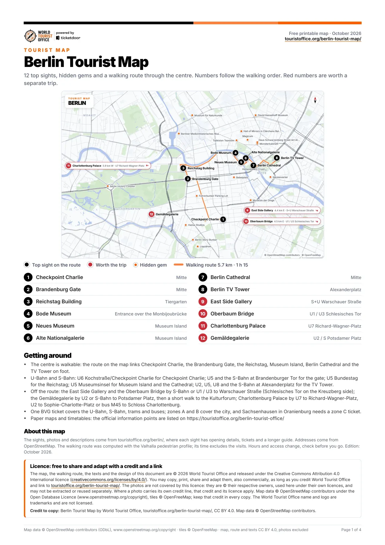
Berlin tourist attractions map, sight by sight
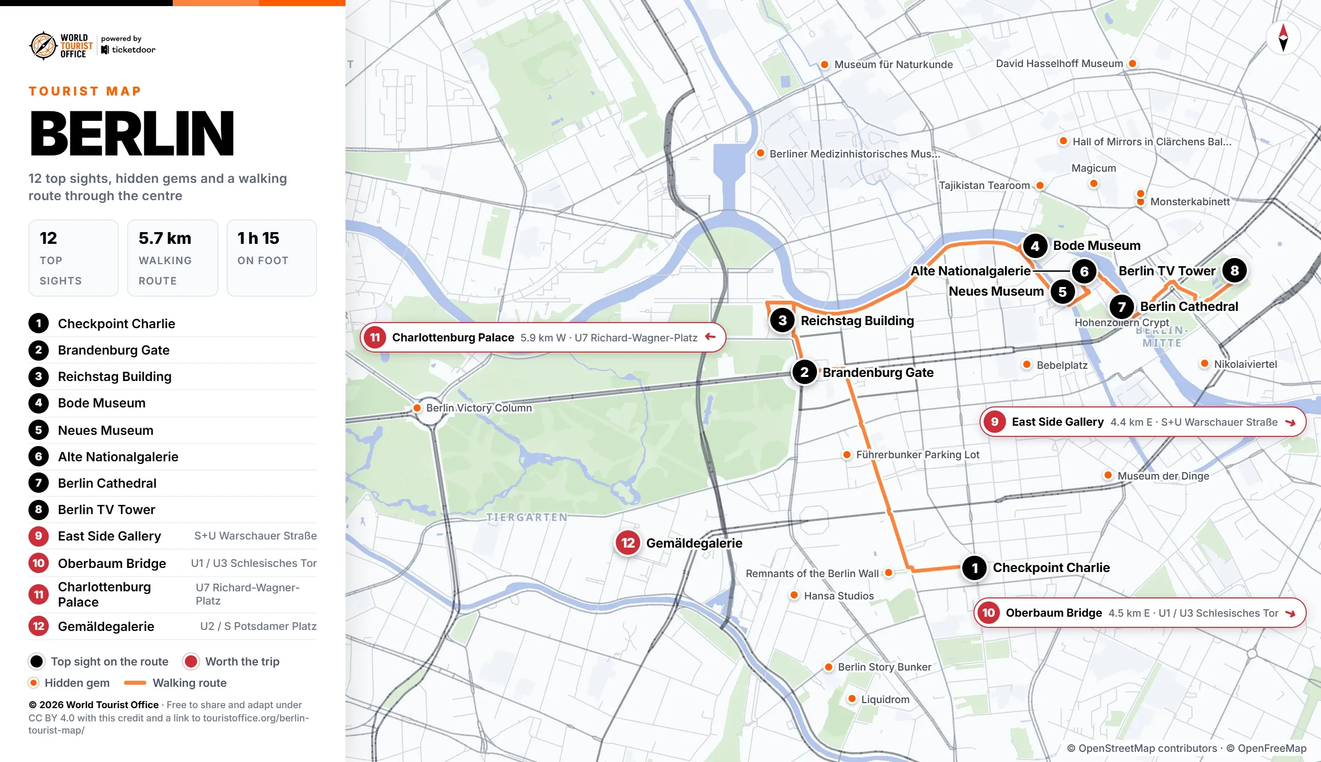
The numbers below match the pins on the map, the PDF and the video. The first 8 sights sit on the walking route through the centre; the other 4 are a U-Bahn or S-Bahn ride away.
- Checkpoint Charlie, Friedrichstraße. The Cold War crossing between the American and Soviet sectors, its guard hut today a reconstruction. Stop 1 of the walking route.
- Brandenburg Gate, Pariser Platz. The 1791 gate crowned by the Quadriga, closing the west end of Unter den Linden. Stop 2 of the walking route.
- Reichstag Building, Tiergarten. The Bundestag under Foster's glass dome; free, but the dome needs a booked slot and photo ID. Stop 3 of the walking route.
- Bode Museum, Museum Island. Ernst von Ihne's domed museum at the island's northern tip, with sculpture and coins; closed Mondays. Stop 4 of the walking route.
- Neues Museum, Museum Island. Chipperfield's rebuilt museum, where the bust of Nefertiti stands under the north cupola; closed Mondays. Stop 5 of the walking route.
- Alte Nationalgalerie, Museum Island. The nineteenth century collection, from Caspar David Friedrich to Monet and Renoir; closed Mondays. Stop 6 of the walking route.
- Berlin Cathedral, Lustgarten. The domed Protestant cathedral; its Hohenzollern crypt reopened in March 2026 after six years of work. Stop 7 of the walking route.
- Berlin TV Tower, Alexanderplatz. The Fernsehturm over Alexanderplatz, the tallest structure in Germany, with a deck 203 metres up. Stop 8 of the walking route.
- East Side Gallery, Friedrichshain. The longest surviving stretch of the Berlin Wall, painted by artists in 1990, along the Spree. Off the route: S-Bahn or U1 and U3 to Warschauer Straße (4.4 km east of the centre).
- Oberbaum Bridge, Friedrichshain-Kreuzberg. Otto Stahn's red brick double-deck bridge, with U1 and U3 trains crossing on the upper level. Off the route: U1 and U3 to Schlesisches Tor or Warschauer Straße (4.5 km east of the centre).
- Charlottenburg Palace, Charlottenburg. The largest surviving royal palace in Berlin, with baroque state apartments and gardens; closed Mondays. Off the route: U7 to Richard-Wagner-Platz or U2 to Sophie-Charlotte-Platz (5.9 km west of the centre).
- Gemäldegalerie, Kulturforum. European painting from the 13th to the 18th century, from Dürer to Vermeer and Caravaggio; closed Mondays. Off the route: U2 or S-Bahn to Potsdamer Platz (1.5 km south-west of the centre).
Hidden gems on the map
Marked in orange on the map: 31 smaller sights worth a detour, 19 of them close to the centre. The 19 central ones come first below, then the nearest one outside the centre; the PDF lists all of them with addresses.
- Monsterkabinett, Rosenthaler Straße
- Haus Schwarzenberg Street Art Alley, Rosenthaler Straße
- The DDR Museum, Karl-Liebknecht-Straße
- Museum für Naturkunde, Invalidenstraße
- Berlin Story Bunker, Schöneberger Straße
- Museum der Dinge, Leipziger Straße
- David Hasselhoff Museum, in the Circus Hostel, Weinbergsweg
- Berliner Medizinhistorisches Museum, Charitéplatz
- Magicum, Große Hamburger Straße
- Tajikistan Tearoom, Oranienburger Straße
- Hall of Mirrors in Clärchens Ballhaus, Auguststraße
- Führerbunker Parking Lot, Gertrud-Kolmar-Straße
- Bebelplatz, on Unter den Linden
- Berlin Victory Column, Großer Stern, Tiergarten
- Liquidrom, inside the Tempodrom, Möckernstraße
- Remnants of the Berlin Wall, Niederkirchnerstraße
- Hohenzollern Crypt, under Berlin Cathedral, Am Lustgarten
- Nikolaiviertel, around the Nikolaikirche
- Hansa Studios, Köthener Straße
- Café Strauss, Bergmannstraße, Kreuzberg
How to reach every sight on the map
The centre is walkable: the 8 stops of the route cover 5.7 km, about 1 h 15 on foot. The two longest legs, 1.6 km each and about 20 minutes, run from Checkpoint Charlie to the Brandenburg Gate and from the Reichstag Building along the Spree to the Bode Museum.
By U-Bahn, Kochstraße/Checkpoint Charlie (U6) serves Checkpoint Charlie, Brandenburger Tor (U5 and S-Bahn) the gate, Bundestag (U5) the Reichstag, Museumsinsel (U5) the museums and the cathedral, and Alexanderplatz (U2, U5, U8 and S-Bahn) the TV Tower. One ticket is valid on the U-Bahn, S-Bahn, trams and buses; zones A and B cover the city.
Sights outside the walking route:
- East Side Gallery: S-Bahn or U1 and U3 to Warschauer Straße, 4.4 km east
- Oberbaum Bridge: U1 and U3 to Schlesisches Tor, on the Kreuzberg side, or Warschauer Straße, 4.5 km east
- Charlottenburg Palace: U7 to Richard-Wagner-Platz, U2 to Sophie-Charlotte-Platz or bus M45 to Schloss Charlottenburg, 5.9 km west
- Gemäldegalerie: U2 or S-Bahn to Potsdamer Platz, then a short walk to the Kulturforum, 1.5 km south-west
Network maps by BVG >
Licence
The map, the PDF, the walking route and the texts are © 2026 World Tourist Office and free to copy, share, print and adapt, also commercially, under Creative Commons Attribution 4.0 International. The only condition is a credit to World Tourist Office with a link to this page.
The photos are not covered by this licence: they are © their respective owners, used here under their own licences, and may not be extracted or reused separately. Where a photo carries its own credit line, that credit and its licence apply. Map data © OpenStreetMap contributors (ODbL), tiles © OpenFreeMap: keep that credit too. The World Tourist Office name and logo are trademarks and are not licensed.
Credit to copy: Berlin Tourist Map by World Tourist Office, touristoffice.org/berlin-tourist-map/, CC BY 4.0. Map data © OpenStreetMap contributors.