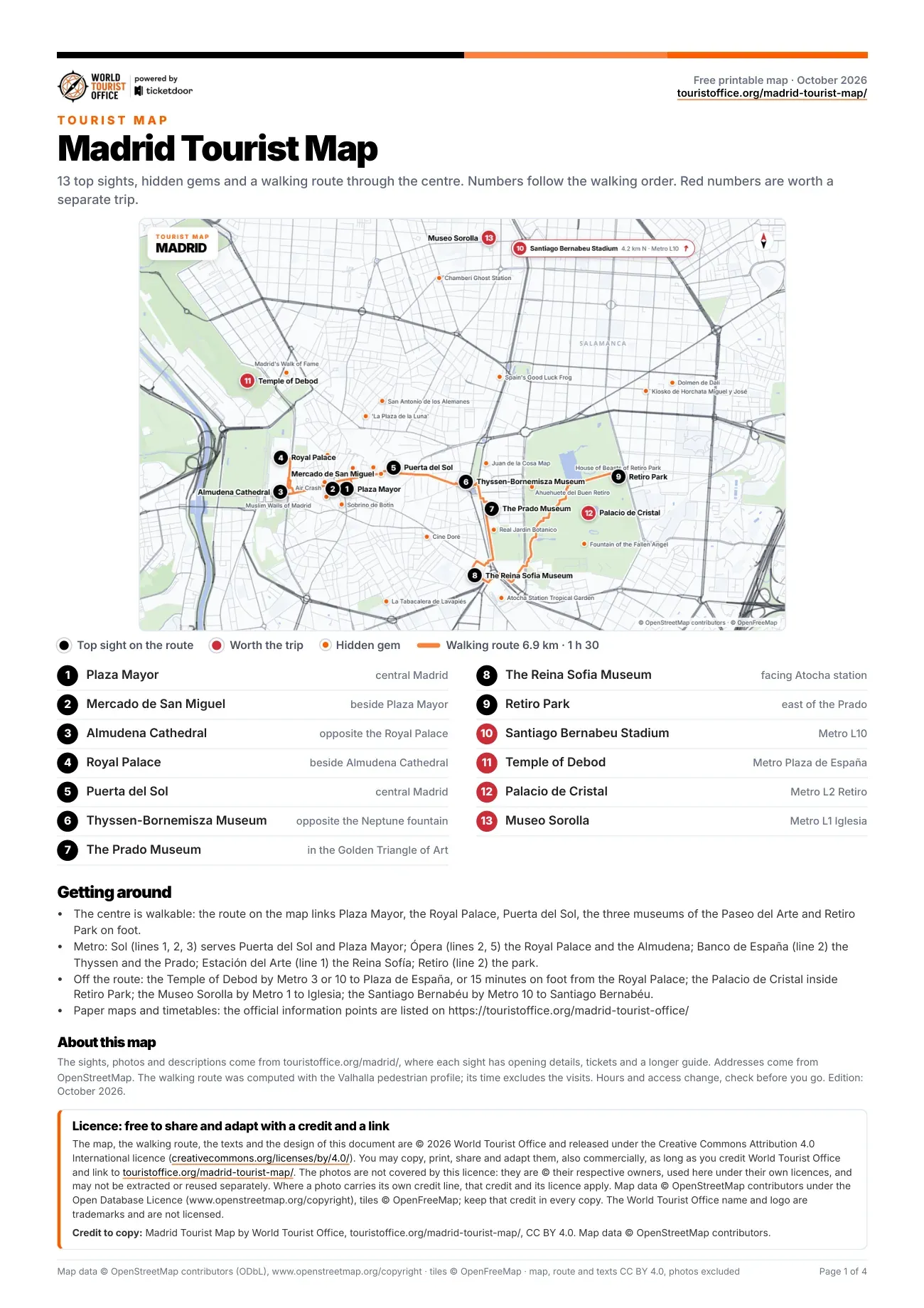
Madrid tourist attractions map, sight by sight
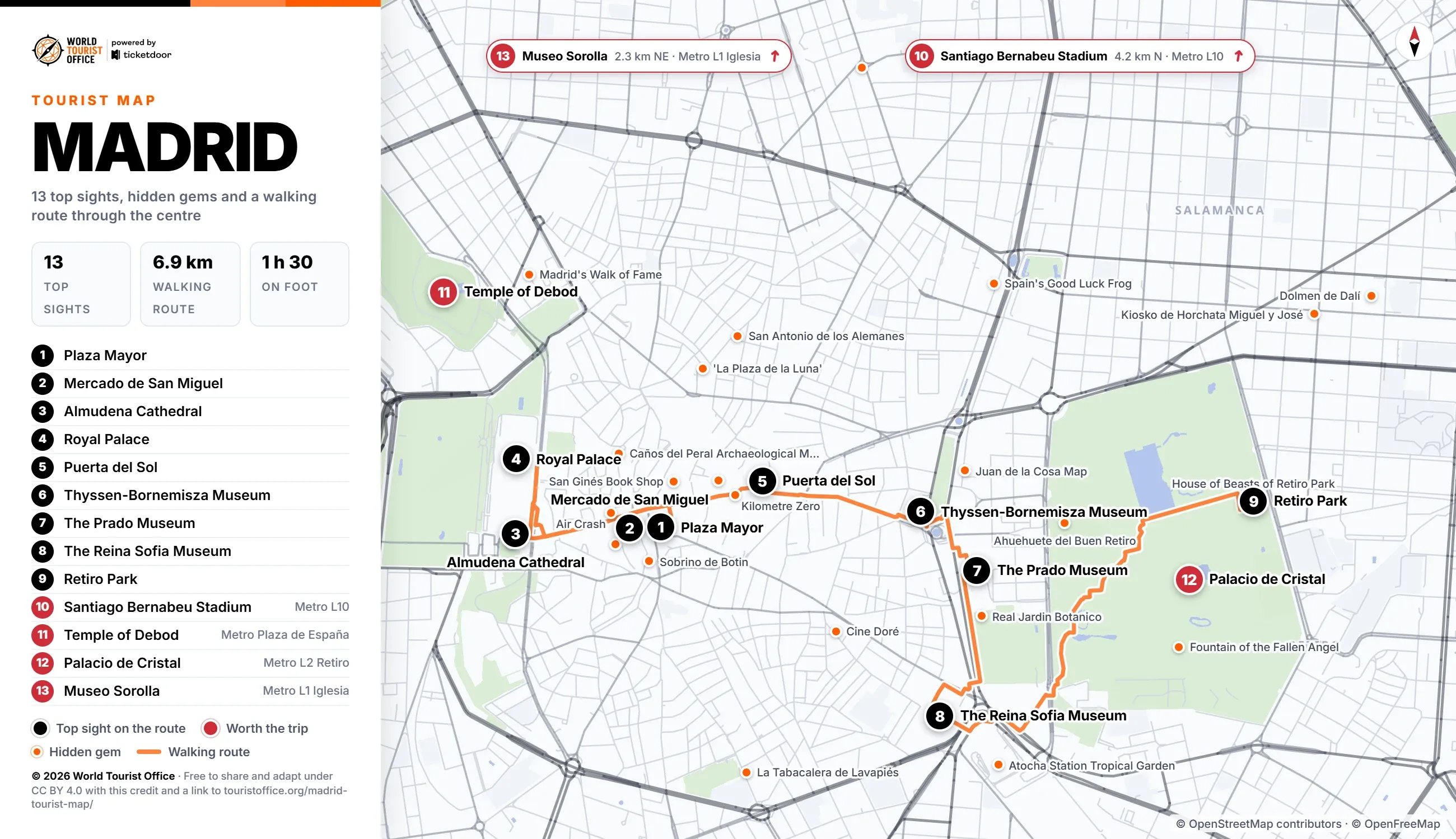
The numbers below match the pins on the map, the PDF and the video. The first 9 sights sit on the walking route through the centre; the last 4 are reached by metro.
- Plaza Mayor, Austrias. The arcaded 17th-century square at the ceremonial heart of Madrid, with a statue of Philip III. Stop 1 of the walking route.
- Mercado de San Miguel, Austrias. An iron and glass market hall of 1916, now a gallery of Spanish food stalls. Stop 2 of the walking route.
- Almudena Cathedral, Austrias. Madrid's cathedral, begun in 1883 and consecrated in 1993, facing the Royal Palace. Stop 3 of the walking route.
- Royal Palace, Austrias. A vast Baroque palace on the site of the old Alcazar, now kept for state ceremonies. Stop 4 of the walking route.
- Puerta del Sol, Sol. The half-moon plaza with the Kilometre Zero slab, the Casa de Correos clock and the bear statue. Stop 5 of the walking route.
- Thyssen-Bornemisza Museum, Paseo del Arte. The third museum of the Golden Triangle of Art, from 13th-century panels to Pop Art. Stop 6 of the walking route.
- The Prado Museum, Paseo del Arte. Spain's national art museum, opened in 1819, with Las Meninas and Goya's Black Paintings. Stop 7 of the walking route.
- The Reina Sofia Museum, Paseo del Arte. The national museum of 20th-century art in a former hospital, home to Picasso's Guernica. Stop 8 of the walking route.
- Retiro Park, Retiro. The former royal garden, on the UNESCO list since 2021, with a boating lake and a rose garden. Stop 9 of the walking route.
- Santiago Bernabeu Stadium, Castellana. Real Madrid's stadium on the Paseo de la Castellana, rebuilt in 2024 with a retractable roof. Off the route: Metro line 10 to Santiago Bernabéu (4.2 km north of the centre).
- Temple of Debod, Princesa. An ancient Egyptian temple given to Spain in 1968 and rebuilt stone by stone near Plaza de España. Off the route: Metro lines 3 and 10 to Plaza de España (1.5 km north-west of the centre).
- Palacio de Cristal, Retiro. An iron and glass pavilion of 1887 beside a lake in Retiro Park, closed for renovation until 2027. Off the route: Metro line 2 to Retiro (1.8 km east of the centre).
- Museo Sorolla, Chamberí. The house and studio of the painter Joaquin Sorolla, closed for renovation, reopening expected late 2026. Off the route: Metro line 1 to Iglesia (2.3 km north-east of the centre).
Hidden gems on the map
Marked in orange on the map: 33 smaller sights worth a detour, 24 of them close to the centre. The PDF lists all of them with addresses.
- Sobrino de Botin, Calle de Cuchilleros
- Atocha Station Tropical Garden, Plaza del Emperador Carlos V
- Fountain of the Fallen Angel, Glorieta del Ángel Caído
- Real Jardin Botanico, Plaza Murillo
- Chamberí Ghost Station, Plaza de Chamberí
- Air Crash, Calle de Santiago
- Witches' Sabbath (The Great He-Goat), Calle de Ruiz de Alarcón
- San Antonio de los Alemanes, Calle de la Puebla
- El Oso y el Madroño (Bear and Strawberry Tree), Puerta del Sol
- Secret Nun Cookies at Monasterio del Corpus Christi, Plaza del Conde de Miranda
- Spain's Good Luck Frog, Paseo de Recoletos
- Juan de la Cosa Map, Paseo del Prado
- Kiosko de Horchata Miguel y José, Calle de Narváez
- La Plaza de la Luna, Plaza de Santa María Soledad Torres Acosta
- Kilometre Zero, Puerta del Sol
- Muslim Walls of Madrid, Plaza Emir Mohamed I
- La Tabacalera de Lavapiés, Calle de Embajadores
- House of Beasts of Retiro Park, Avenida de Menéndez Pelayo
- Madrid's Walk of Fame, Calle de Martín de los Heros
- Ahuehuete del Buen Retiro ("El Abuelo"), Calle de Alfonso XII
Walking, metro and buses between the sights
The centre is walkable: the 9 stops on the route cover 6.9 km, about 1 h 30 of walking without the visits, and the longest leg is the 2.2 km from the Reina Sofia to Retiro Park.
Metro de Madrid lines cross the route at several points. Sol, on lines 1, 2 and 3, serves Puerta del Sol and Plaza Mayor, and Ópera, on lines 2 and 5, the Royal Palace and Almudena Cathedral. Along the Paseo del Arte, Banco de España on line 2 serves the Thyssen-Bornemisza and the Prado, and Estación del Arte on line 1 the Prado and the Reina Sofia. Retiro, on line 2, serves the park.
Sights outside the walking route:
- Santiago Bernabeu Stadium: Metro line 10 to Santiago Bernabéu, 4.2 km north
- Temple of Debod: Metro lines 3 and 10 to Plaza de España, 1.5 km north-west
- Palacio de Cristal: Metro line 2 to Retiro or line 9 to Ibiza, closed until 2027, 1.8 km east
- Museo Sorolla: Metro line 1 to Iglesia, closed for renovation, 2.3 km north-east
Metro de Madrid network map >
Licence
The map, the PDF, the walking route and the texts are © 2026 World Tourist Office and free to copy, share, print and adapt, also commercially, under Creative Commons Attribution 4.0 International. The only condition is a credit to World Tourist Office with a link to this page.
The photos are not covered by this licence: they are © their respective owners, used here under their own licences, and may not be extracted or reused separately. Where a photo carries its own credit line, that credit and its licence apply. Map data © OpenStreetMap contributors (ODbL), tiles © OpenFreeMap: keep that credit too. The World Tourist Office name and logo are trademarks and are not licensed.
Credit to copy: Madrid Tourist Map by World Tourist Office, touristoffice.org/madrid-tourist-map/, CC BY 4.0. Map data © OpenStreetMap contributors.