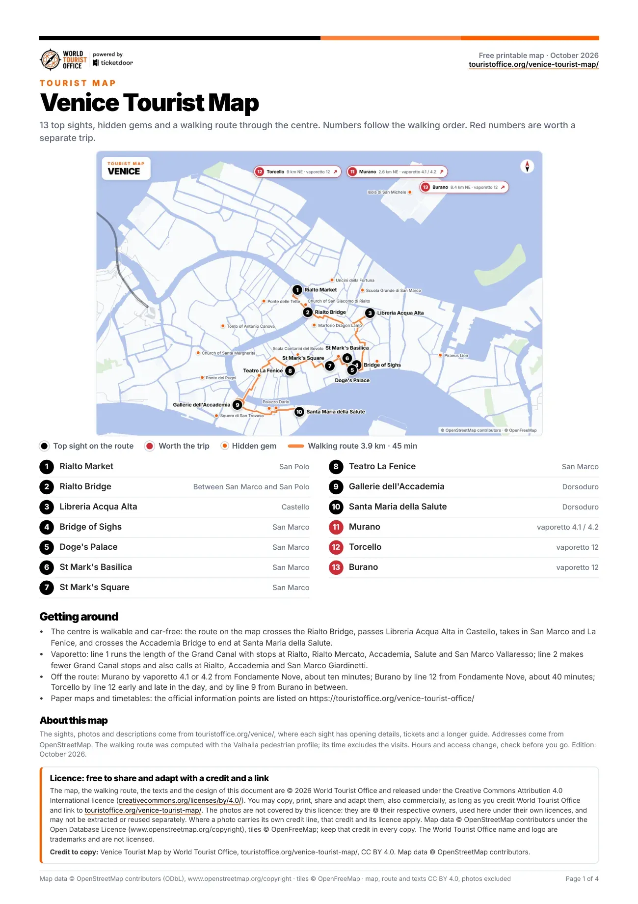
Venice tourist attractions map, sight by sight
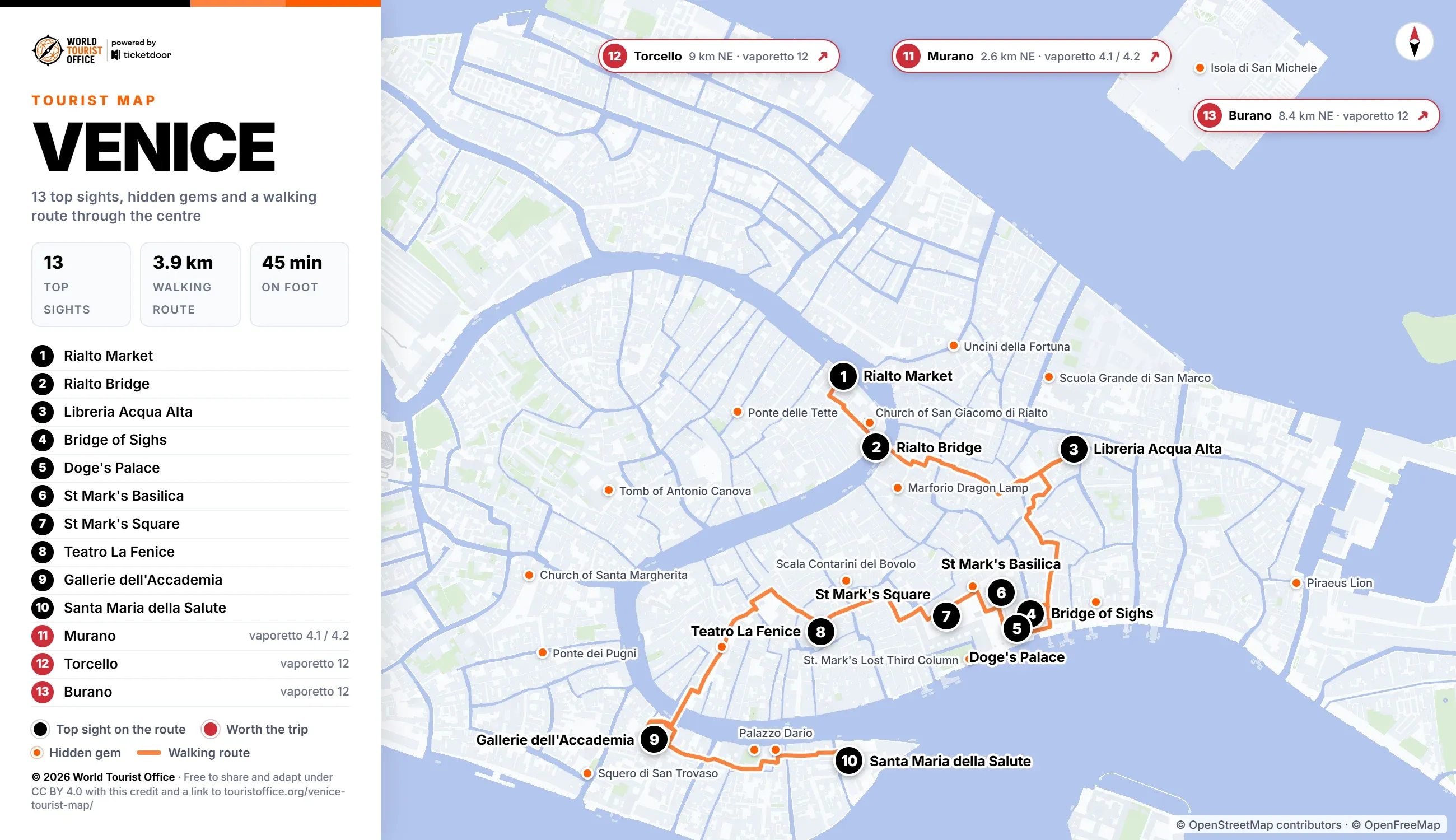
The numbers below match the pins on the map, the PDF and the video. The first 10 sights sit on the walking route through the centre and are all reached on foot; the other 3 are islands in the northern lagoon, reached by vaporetto.
- Rialto Market, San Polo. Fish, fruit and vegetables under the Erberia arcades and in the neo-Gothic Pescheria, closed on Sunday. Stop 1 of the walking route.
- Rialto Bridge, the Grand Canal between San Marco and San Polo. Antonio da Ponte's single stone arch of 1591, with two rows of shops along its ramps. Stop 2 of the walking route.
- Libreria Acqua Alta, Castello. A bookshop that keeps its stock in a gondola, bathtubs and waterproof bins, free to browse. Stop 3 of the walking route.
- Bridge of Sighs, San Marco. Antonio Contin's enclosed bridge from the palace to the prisons, seen from the Ponte della Paglia. Stop 4 of the walking route.
- Doge's Palace, San Marco. The seat of Venetian government, with rooms hung with Tintoretto and Veronese and the old prisons. Stop 5 of the walking route.
- St Mark's Basilica, San Marco. Five domes and nearly 8,000 square metres of gold mosaic, with timed entry in the booked slot. Stop 6 of the walking route.
- St Mark's Square, San Marco. The only piazza in Venice, with the Campanile, the Torre dell'Orologio and the Procuratie arcades. Stop 7 of the walking route.
- Teatro La Fenice, San Marco. The opera house of 1792, burned twice and rebuilt, where Verdi premiered Rigoletto and La traviata. Stop 8 of the walking route.
- Gallerie dell'Accademia, Dorsoduro. Venetian painting from the 14th to the 18th century, Bellini to Veronese, closed on Monday. Stop 9 of the walking route.
- Santa Maria della Salute, Dorsoduro. Longhena's octagonal church at the mouth of the Grand Canal, vowed after the plague of 1630. Stop 10 of the walking route.
- Murano, northern lagoon. The glass-making islands since 1291, with furnaces, the Museo del Vetro and Santi Maria e Donato. Off the route: vaporetto 4.1 or 4.2 from Fondamente Nove (2.6 km north-east of the centre).
- Torcello, northern lagoon. The lagoon's first city, settled in the 5th century, with the mosaics of Santa Maria Assunta. Off the route: vaporetto 12 from Fondamente Nove, or by day line 12 to Burano and the line 9 shuttle (9.0 km north-east of the centre).
- Burano, northern lagoon. Fishermen's houses painted in blocks of colour, and the Lace Museum on Piazza Galuppi. Off the route: vaporetto 12 from Fondamente Nove (8.4 km north-east of the centre).
Hidden gems on the map
The map marks 19 of the 29 hidden gems in orange. The other 10 lie outside its frame, on the lagoon islands, and the PDF gives their distance from the centre. The 19 on the map are listed below with the nearest one outside it, on Murano; the PDF gives all 29 with addresses.
- St. Mark's Clock Tower (Torre dell'Orologio), Piazza San Marco
- The Flooded Crypt of San Zaccaria, Campo San Zaccaria
- Scala Contarini del Bovolo, Corte Contarini del Bovolo
- Tomb of Antonio Canova, Campo dei Frari
- Palazzo Dario, Ramo Ca' Dario
- Ponte dei Pugni (Bridge of Fists), by Campo San Barnaba
- St. Mark's Lost Third Column, Piazzetta San Marco
- Piraeus Lion, Campo de l'Arsenal
- Isola di San Michele, the cemetery island in the northern lagoon
- Ponte delle Tette, Calle Agnello
- Portrait of the Four Tetrarchs, Piazzetta San Marco
- Scuola Grande di San Marco, Campo Santi Giovanni e Paolo
- Squero di San Trovaso, Campo San Trovaso
- Peggy Guggenheim's Grave, Palazzo Venier dei Leoni
- Church of San Giacomo di Rialto, Campo San Giacomo di Rialto
- Monument to Niccolò Tommaseo, Campo Santo Stefano
- Church of Santa Margherita, Campo Santa Margherita
- Uncini della Fortuna (Hooks of Fortune), Ponte San Canciano
- Marforio Dragon Lamp, Marzarieta Due Aprile
- 'Dragon Bones' of Santa Maria e San Donato, Campo San Donato, Murano
How to get around Venice with this map
The centre is car-free and walkable: the 10 stops of the route cover 3.9 km, about 45 min on foot without the visits. The route crosses the Grand Canal twice, on the Rialto Bridge and on the Ponte dell'Accademia, and the longest leg, 0.8 km and about 9 minutes, runs from Teatro La Fenice over the Accademia bridge to the Gallerie dell'Accademia.
On the water, ACTV vaporetto line 1 runs the length of the Grand Canal with stops at Rialto Mercato, Rialto, Santa Maria del Giglio, Accademia, Salute and San Marco Vallaresso. Line 2 calls at Rialto, Accademia and San Marco Giardinetti, and the San Marco-San Zaccaria stop on the waterfront is served by lines 1, 2, 4.1 and 4.2.
Sights outside the walking route:
- Murano: vaporetto 4.1 or 4.2 from Fondamente Nove, about 10 minutes to Murano Colonna, 2.6 km north-east
- Torcello: vaporetto 12 from Fondamente Nove on early and evening runs; by day, line 12 to Burano and the line 9 shuttle, 9.0 km north-east
- Burano: vaporetto 12 from Fondamente Nove via Murano Faro and Mazzorbo, about 40 minutes, 8.4 km north-east
Vaporetto route maps by ACTV (in Italian) >
Licence
The map, the PDF, the walking route and the texts are © 2026 World Tourist Office and free to copy, share, print and adapt, also commercially, under Creative Commons Attribution 4.0 International. The only condition is a credit to World Tourist Office with a link to this page.
The photos are not covered by this licence: they are © their respective owners, used here under their own licences, and may not be extracted or reused separately. Where a photo carries its own credit line, that credit and its licence apply. Map data © OpenStreetMap contributors (ODbL), tiles © OpenFreeMap: keep that credit too. The World Tourist Office name and logo are trademarks and are not licensed.
One photo in the PDF and the video carries its own credit: Gallerie dell'Accademia, "Gallerie dell'Accademia" by Didier Descouens, licensed under CC BY-SA 4.0.
Credit to copy: Venice Tourist Map by World Tourist Office, touristoffice.org/venice-tourist-map/, CC BY 4.0. Map data © OpenStreetMap contributors.