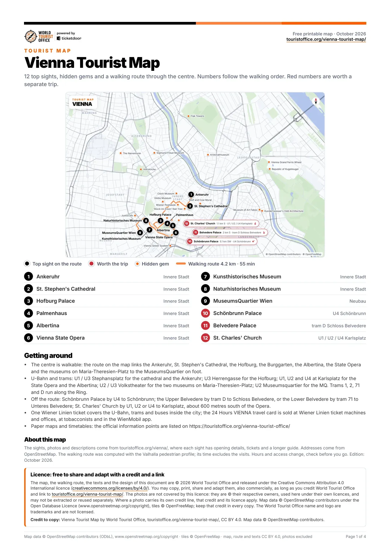
The 12 sights on the Vienna attractions map
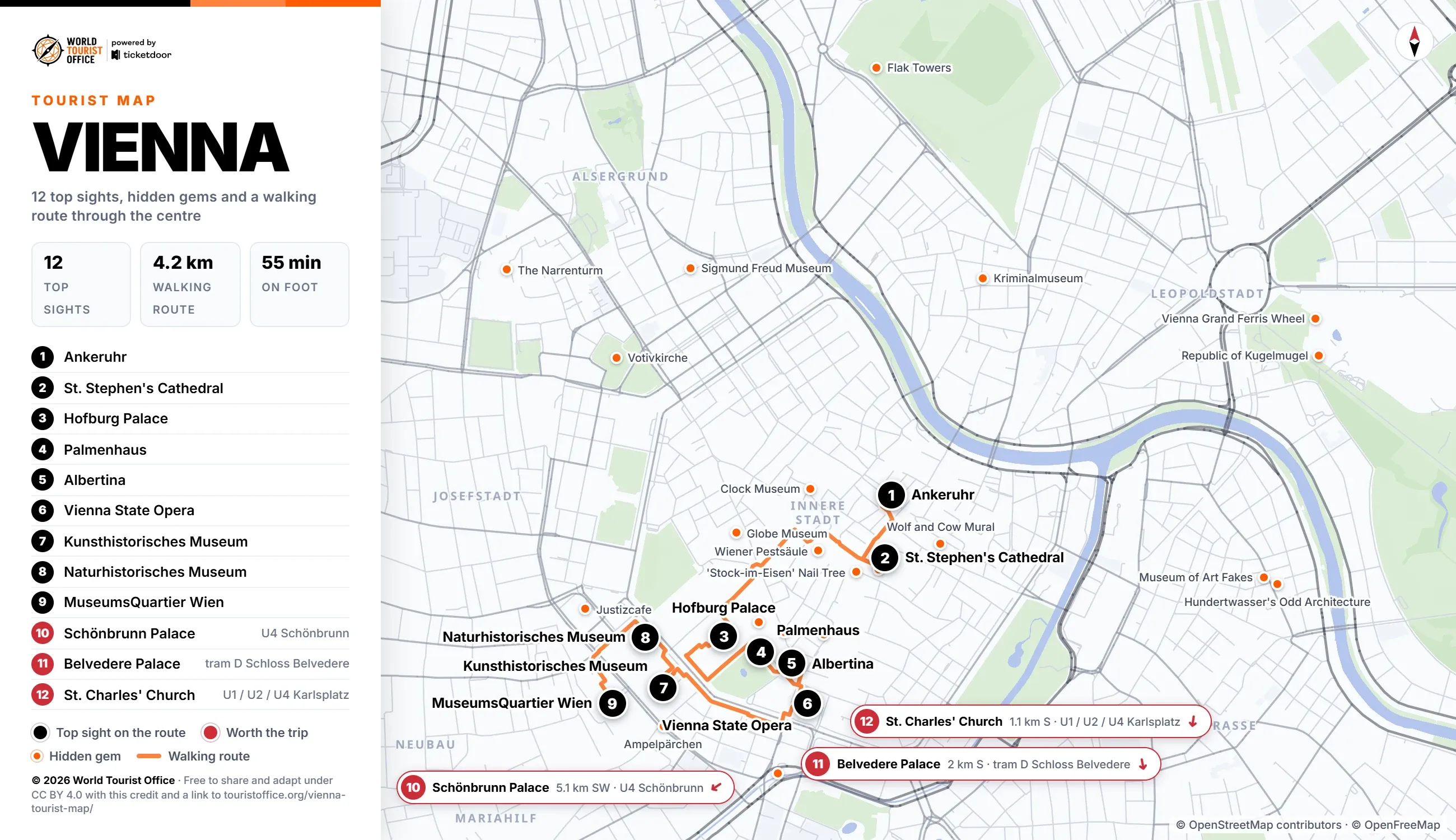
The numbers below match the pins on the map, the PDF and the video. The first 9 sights sit on the walking route through the centre; the other 3 are a U-Bahn or tram ride away.
- Ankeruhr, Innere Stadt. An Art Nouveau clock on Hoher Markt where twelve historical figures cross its face, all at noon. Stop 1 of the walking route.
- St. Stephen's Cathedral, Innere Stadt. The old city's cathedral, with its 136 metre south tower; the rear of the nave is free. Stop 2 of the walking route.
- Hofburg Palace, Innere Stadt. The Habsburg city palace, with the Imperial Apartments, the Sisi Museum and the Silver Collection. Stop 3 of the walking route.
- Palmenhaus, Innere Stadt. An Art Nouveau glasshouse in the Burggarten, now a brasserie, with the Butterfly House in one wing. Stop 4 of the walking route.
- Albertina, Innere Stadt. A Habsburg palace on the last bastion of the old city walls, with its prints and drawings. Stop 5 of the walking route.
- Vienna State Opera, Innere Stadt. The first great building finished on the Ringstrasse, opened in 1869, with daytime guided tours. Stop 6 of the walking route.
- Kunsthistorisches Museum, Innere Stadt. The imperial art collection on Maria-Theresien-Platz, with the largest group of Bruegel paintings anywhere. Stop 7 of the walking route.
- Naturhistorisches Museum, Innere Stadt. The natural history twin across Maria-Theresien-Platz, home of the Venus of Willendorf; closed on Tuesdays. Stop 8 of the walking route.
- MuseumsQuartier Wien, Neubau. The former imperial court stables, now a quarter of museums with the Leopold Museum and mumok. Stop 9 of the walking route.
- Schönbrunn Palace, Hietzing. The Habsburg summer residence, a UNESCO World Heritage Site, with the Gloriette above its gardens. Off the route: U4 to Schönbrunn (5.1 km south-west of the centre).
- Belvedere Palace, Landstraße. Two baroque palaces linked by terraced gardens; the Upper Belvedere holds Klimt's The Kiss. Off the route: tram D to Schloss Belvedere (2.0 km south of the centre).
- St. Charles' Church, Wieden. A baroque church vowed against the plague of 1713, with two columns modelled on Trajan's Column. Off the route: U1, U2 or U4 to Karlsplatz (1.1 km south of the centre).
Hidden gems on the map
The map marks 23 of the 28 hidden gems in orange. The other 5, The Lost Garden of Schloss Schönbrunn, Gasometer Town, the Jubiläumswarte, Wotruba Church and the Cemetery of the Nameless, lie outside its frame and appear in the PDF with their distance from the centre. Twenty of the 23 on the map are listed below; the PDF gives all 28 with addresses.
- Österreichische Nationalbibliothek, the Prunksaal on Josefsplatz, in a wing of the Hofburg
- Hundertwasser's Odd Architecture, Kegelgasse
- Republic of Kugelmugel, Antifaschismusplatz, in the Prater
- Vienna Grand Ferris Wheel, Riesenradplatz, in the Prater
- 'Stock-im-Eisen' Nail Tree, Stock-im-Eisen-Platz
- Votivkirche, Rooseveltplatz
- Wolf and Cow Playing Backgammon Mural, Bäckerstraße
- Vienna Sewer System, tours start in the Girardipark by Karlsplatz
- Ampelpärchen, at pedestrian crossings around the Ring
- Flak Towers, Augarten, Esterházypark and Arenbergpark
- Justizcafe, Schmerlingplatz
- Stephansdom Crypt, under St. Stephen's Cathedral (2), Stephansplatz
- Habsburg Imperial Crypt, Tegetthoffstraße
- Kriminalmuseum, Große Sperlgasse
- Wiener Pestsäule, on the Graben
- Ungarisches Haus, Augustinerstraße
- Schmetterlinghaus, inside the Palmenhaus (4), Burggarten
- Clock Museum, Schulhof
- The Narrenturm, Spitalgasse
- Sigmund Freud Museum, Berggasse
Walking, metro and buses between the sights
The centre is walkable: the 9 stops of the route cover 4.2 km, about 55 min on foot without the visits. The longest leg, 1.1 km and about 13 minutes, runs from St. Stephen's Cathedral along the Graben to the Hofburg Palace.
On the U-Bahn, Stephansplatz (U1 and U3) serves the cathedral and the Ankeruhr, Herrengasse (U3) the Hofburg Palace, Karlsplatz (U1, U2 and U4) the Vienna State Opera and the Albertina, Volkstheater (U2 and U3) the two museums on Maria-Theresien-Platz and Museumsquartier (U2) the MuseumsQuartier Wien. Trams 1, 2, D and 71 run along the Ring with stops at the Opera and at Burgring, and city buses 1A, 2A and 3A stop at Hoher Markt, by the Ankeruhr. One ticket covers the U-Bahn, trams and city buses.
Sights outside the walking route:
- Schönbrunn Palace: U4 to Schönbrunn, 5.1 km south-west
- Belvedere Palace: tram D to Schloss Belvedere for the Upper Belvedere, or tram 71 to Unteres Belvedere for the Lower Belvedere, 2.0 km south
- St. Charles' Church: U1, U2 or U4 to Karlsplatz, 1.1 km south
Network maps by Wiener Linien >
Licence
The map, the PDF, the walking route and the texts are © 2026 World Tourist Office and free to copy, share, print and adapt, also commercially, under Creative Commons Attribution 4.0 International. The only condition is a credit to World Tourist Office with a link to this page.
The photos are not covered by this licence: they are © their respective owners, used here under their own licences, and may not be extracted or reused separately. Where a photo carries its own credit line, that credit and its licence apply. Map data © OpenStreetMap contributors (ODbL), tiles © OpenFreeMap: keep that credit too. The World Tourist Office name and logo are trademarks and are not licensed.
Credit to copy: Vienna Tourist Map by World Tourist Office, touristoffice.org/vienna-tourist-map/, CC BY 4.0. Map data © OpenStreetMap contributors.